
|
For the North Atlantic...Caribbean Sea and the Gulf of Mexico:
The National Hurricane Center is issuing advisories on Tropical Storm Leslie, located over the central Atlantic Ocean. Tropical cyclone formation is not expected during the next 5 days. SUMMARY OF 100 PM CDT…1800 UTC…INFORMATION
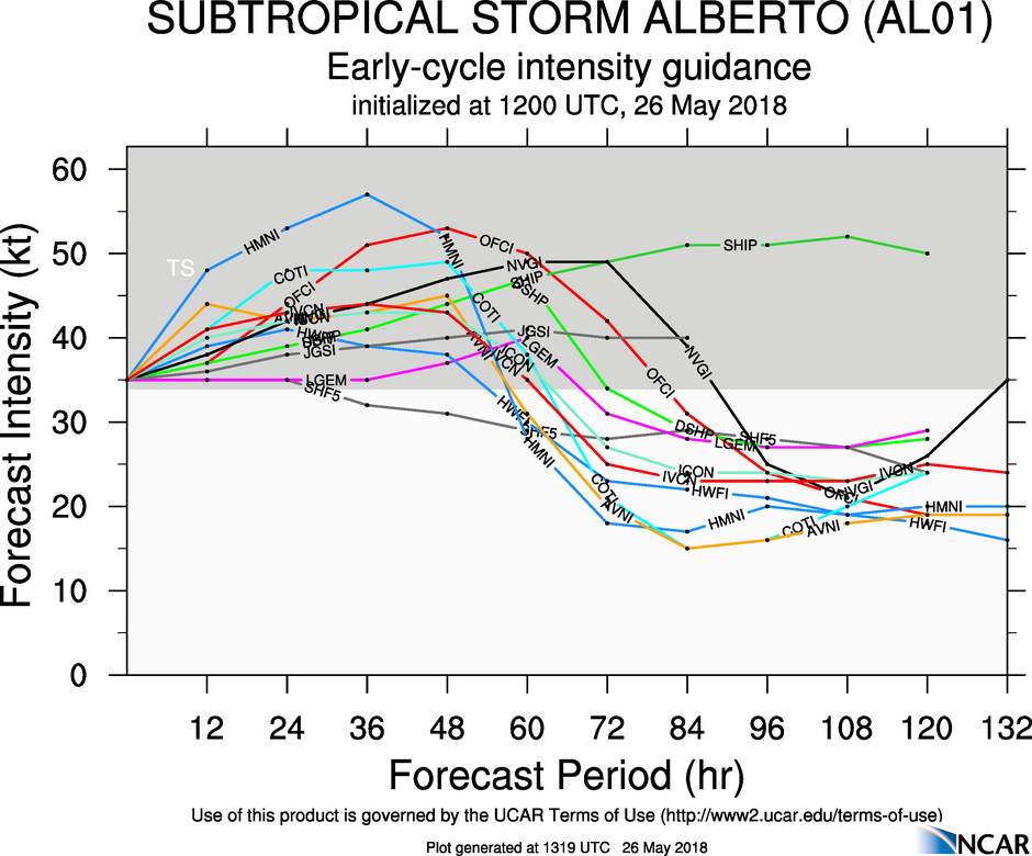
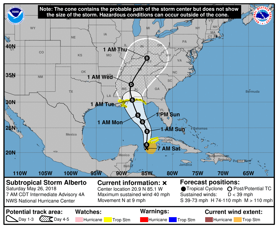
———————————————- LOCATION…28.9N 87.3W ABOUT 130 MI…205 KM SSE OF MOBILE ALABAMA ABOUT 145 MI…235 KM SE OF BILOXI MISSISSIPPI MAXIMUM SUSTAINED WINDS…65 MPH…100 KM/H PRESENT MOVEMENT…NW OR 305 DEGREES AT 15 MPH…24 KM/H MINIMUM CENTRAL PRESSURE…1001 MB…29.56 INCHES WATCHES AND WARNINGS ——————– CHANGES WITH THIS ADVISORY: None. SUMMARY OF WATCHES AND WARNINGS IN EFFECT: A Storm Surge Warning is in effect for… * Shell Beach to Dauphin Island A Storm Surge Watch is in effect for… * West of Shell Beach to the Mouth of the Mississippi River * East of Dauphin Island to Navarre A Hurricane Warning is in effect for… * Mouth of the Pearl River to the Alabama-Florida Border A Tropical Storm Warning is in effect for… * West of the Mouth of the Pearl River to Grand Isle, including Lake Pontchartrain and Lake Maurepas * Alabama-Florida Border to Okaloosa-Walton County Line A Storm Surge Warning means there is a danger of life-threatening inundation, from rising water moving inland from the coastline, in the indicated locations. For a depiction of areas at risk, please see the National Weather Service Storm Surge Watch/Warning Graphic, available at hurricanes.gov. This is a life-threatening situation. Persons located within these areas should take all necessary actions to protect life and property from rising water and the potential for other dangerous conditions. Promptly follow evacuation and other instructions from local officials. A Storm Surge Watch means there is a possibility of life- threatening inundation, from rising water moving inland from the coastline, in the indicated locations. A Hurricane Warning means that hurricane conditions are expected somewhere within the warning area. Preparations to protect life and property should be rushed to completion. A Tropical Storm Warning means that tropical storm conditions are expected somewhere within the warning areas. For storm information specific to your area, including possible inland watches and warnings, please monitor products issued by your local National Weather Service forecast office. DISCUSSION AND OUTLOOK ———————- At 100 PM CDT (1800 UTC), the center of Tropical Storm Gordon was located near latitude 28.9 North, longitude 87.3 West. Gordon is moving toward the northwest near 15 mph (24 km/h), and this general motion is expected to continue until landfall occurs tonight along the north-central Gulf coast. A northwestward motion with some decrease in forward speed is expected after landfall, with a gradual turn toward the north-northwest and north forecast to occur on Friday. On the forecast track, the center of Gordon will move across the northern Gulf of Mexico today, and will approach the north- central Gulf Coast within the hurricane warning area late this afternoon or evening, and move inland over the lower Mississippi Valley tonight and early Wednesday. Reports from an Air Force Reserve Unit reconnaissance aircraft indicate that maximum sustained winds remain near 65 mph (100 km/h) with higher gusts. Some strengthening is expected later today, and Gordon is forecast to be a hurricane when it makes landfall along the north-central Gulf Coast. Rapid weakening is forecast after Gordon moves inland. Tropical-storm-force winds extend outward up to 80 miles (130 km) from the center. The minimum central pressure is estimated to be 1001 mb (29.56 inches) based on recent reconnaissance aircraft data. HAZARDS AFFECTING LAND ———————- STORM SURGE: The combination of a dangerous storm surge and the tide will cause normally dry areas near the coast to be flooded by rising waters moving inland from the shoreline. The water could reach the following heights above ground somewhere in the indicated areas if the peak surge occurs at the time of high tide… Shell Beach to Dauphin Island…3 to 5 ft. Navarre Florida to Dauphin Island, including Mobile Bay…2 to 4 ft. Shell Beach to the Mouth of Mississippi River…2 to 4 ft. Mouth of the Mississippi River to the Louisiana-Texas border…1 to 2 ft. The deepest water will occur along the immediate coast near and to the east of the landfall location, where the surge will be accompanied by large waves. Surge-related flooding depends on the relative timing of the surge and the tidal cycle, and can vary greatly over short distances. For information specific to your area, please see products issued by your local National Weather Service forecast office. RAINFALL: Gordon is expected to produce total rain accumulations of 4 to 8 inches over the western Florida Panhandle, southwest Alabama, southern and central Mississippi, northeastern Louisiana, and southern Arkansas, with isolated maximum amounts of 12 inches through late Thursday. This rainfall will cause flash flooding across portions of these areas. WIND: Tropical storm conditions are expected to begin this afternoon within portions of the warning area, with hurricane conditions expected by this evening in the hurricane warning area. TORNADOES: A few tornadoes are possible this afternoon through tonight near the coasts of Mississippi, Alabama, and the Florida Panhandle. NEXT ADVISORY ————- Next complete advisory at 400 PM CDT. For the North Atlantic...Caribbean Sea and the Gulf of Mexico: 1. A tropical wave is forecast to move off the west coast of Africa late Thursday or early Friday, with an area of low pressure likely to form between the coast of Africa and the Cabo Verde Islands. Development of this system is possible over the weekend while it moves west-northwestward over the eastern tropical Atlantic Ocean. Development could be limited early next week when the system reaches cooler waters west of the Cabo Verde Islands. * Formation chance through 48 hours...low...near 0 percent. * Formation chance through 5 days...low...30 percent. 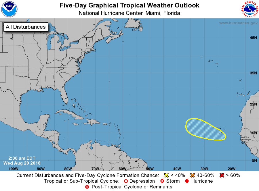 Tropical cyclone formation is not expected for the next five days. 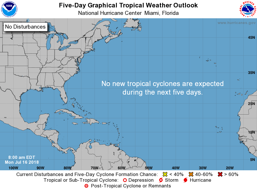 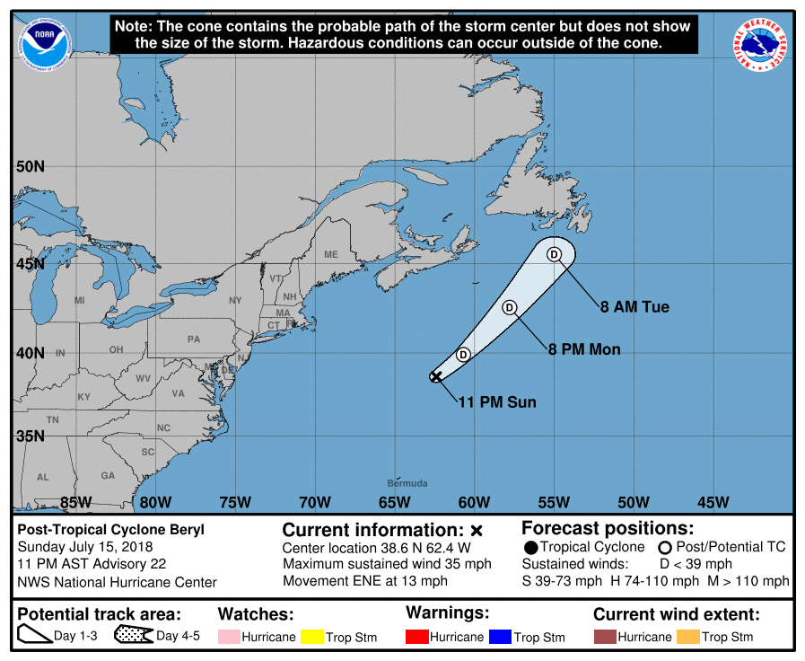 The Remnants of Beryl continues die way east of the United States as it moves Northeast at 13 mph. No threat to land at all as it continues into the Northern Atlantic. The Atlantic Basin remains very quiet, and no new tropical cyclones are expected for the next five days. 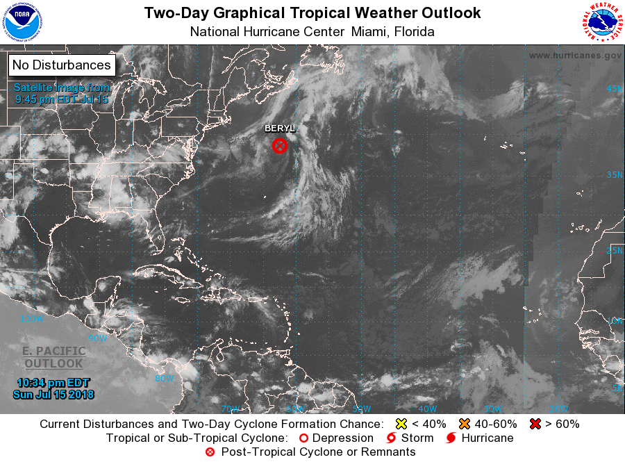 Alberto continues to move northward through the gulf as a subtropical cyclone this morning with a disorganized structure and loss of thunderstorm activity overnight. Maximum sustained winds continues to remain at 40 mph. 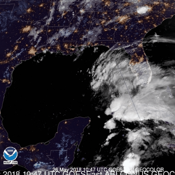 WHAT YOU NEED TO KNOW:
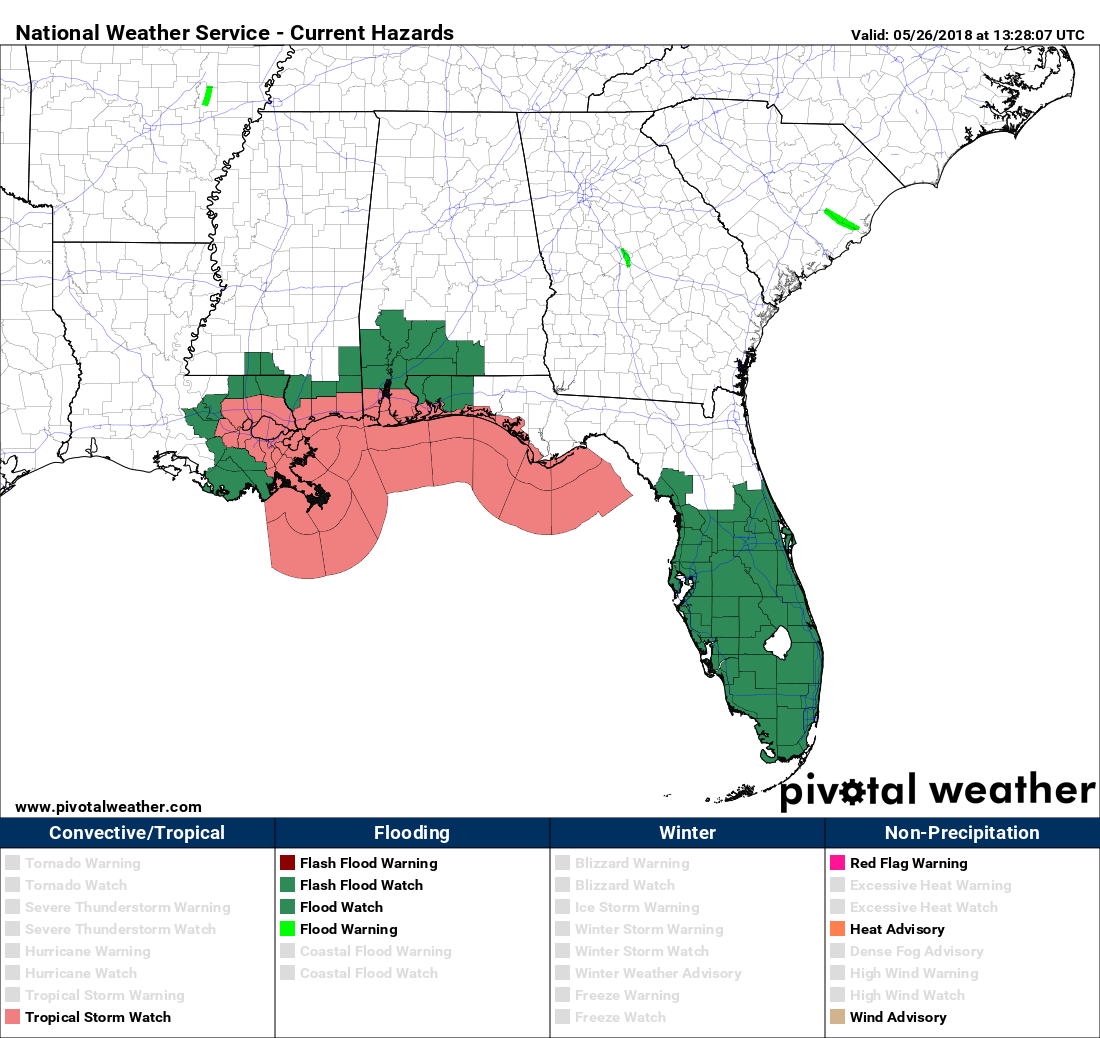 Flash flood watches cover much of Southern Florida through the coast of Louisiana, Mississippi, Alabama, and Florida. The flood threat will be maximized for areas closer to the coast where 6 to 12 inches of rainfall is expected. Areas more inland could still experience 3 to 6 inches. 
As we get closer to the landfall of Alberto, just make sure that you are consistently working with fresh information. As I always say, if you are looking at a forecast that is more than six hours old, you are looking at bad information. For the North Atlantic...Caribbean Sea and the Gulf of Mexico: 1. Satellite-derived wind data indicate that a sharp surface trough of low pressure lies over the southwestern Atlantic Ocean, with an associated area of disorganized showers and thunderstorms extending from Puerto Rico northward to near Bermuda. Although tropical cyclone development is becoming less likely due to strong upper- level winds, this disturbance is forecast to merge with a cold front over the western Atlantic by tonight, and a non-tropical area of low pressure is expected to develop along the front and move toward the north Atlantic during the next few days. * Formation chance through 48 hours...low...20 percent. * Formation chance through 5 days...low...20 percent.  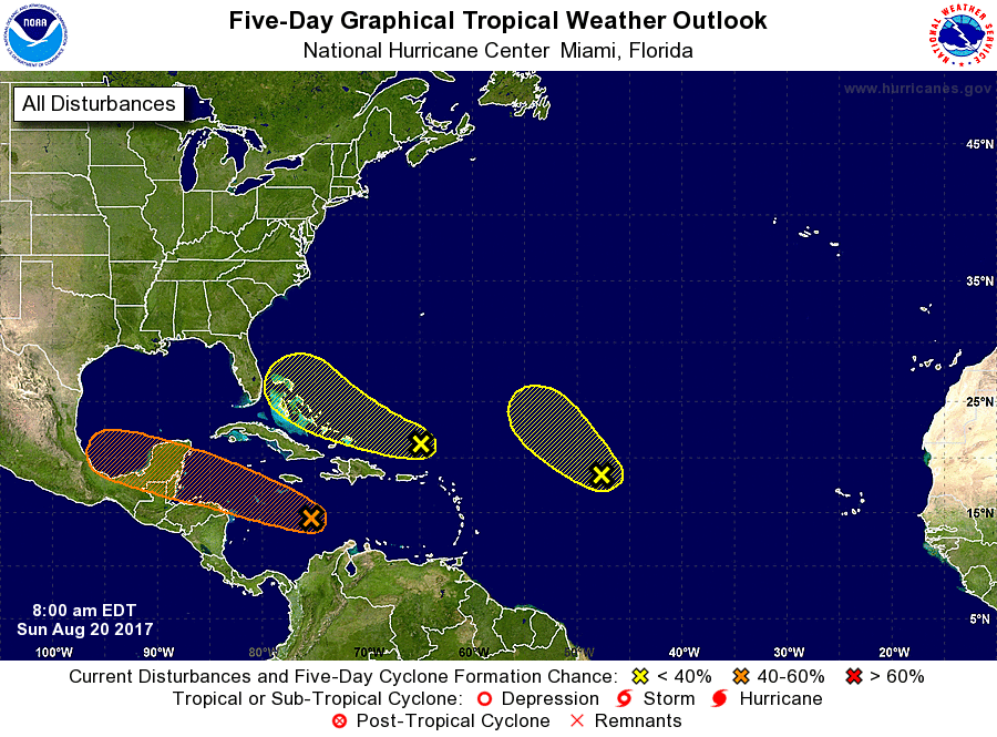 For the North Atlantic...Caribbean Sea and the Gulf of Mexico:
1. Showers and thunderstorms have increased this morning in association with the remnants of Harvey. Gradual development of this system is possible, and it could become a tropical cyclone once again as it moves west-northwestward across the central and northwestern Caribbean Sea during the next couple of days. Interests in northern Nicaragua, Honduras, Belize, and the Yucatan peninsula should monitor the progress of this system. An Air Force Reserve reconnaissance aircraft is scheduled to investigate this disturbance later today. * Formation chance through 48 hours...medium...50 percent * Formation chance through 5 days...medium...60 percent 2. A trough of low pressure located a couple of hundred miles north of Puerto Rico continues to produce disorganized showers and thunderstorms. Environmental conditions are expected to be unfavorable for development of this system during the next couple of days, but they could become slightly more conducive for development by midweek when the system is near the northwestern Bahamas or Florida. * Formation chance through 48 hours...low...10 percent. * Formation chance through 5 days...low...20 percent. 3. A large area of cloudiness and disorganized thunderstorms located about 1000 miles east of the northern Leeward Islands is associated with a trough of low pressure. This system is currently embedded in a dry air mass, and upper-level winds are expected to become too strong to support development in a day or so. Therefore, tropical cyclone formation is not likely while this system moves northwestward at about 15 mph. * Formation chance through 48 hours...low...10 percent. * Formation chance through 5 days...low...10 percent. For the North Atlantic...Caribbean Sea and the Gulf of Mexico: 1. Showers and thunderstorms are showing some signs of organization in association with a strong tropical wave located over the west-central Caribbean Sea. This system is moving west-northwestward at 10 to 15 mph, and a tropical depression or tropical storm could form over the northwestern Caribbean Sea before it reaches the Yucatan Peninsula of Mexico late Monday or early Tuesday. Even if formation does not occur before the system reaches the Yucatan peninsula, a tropical depression or tropical storm could form over the Bay of Campeche by midweek. The Air Force Reserve reconnaissance aircraft scheduled for today has been canceled, but a new mission has been scheduled for Monday, if necessary. Interests along the coasts of Honduras, Belize, and the Yucatan Peninsula should monitor the progress of this disturbance. * Formation chance through 48 hours...medium...60 percent. * Formation chance through 5 days...high...80 percent. 2. An area of low pressure located about midway between the Cabo Verde Islands and the Lesser Antilles remains elongated, and the associated showers and thunderstorms are not well organized. Some slow development of this system is possible during the next several days while it moves generally west-northwestward across the tropical Atlantic at about 15 mph. * Formation chance through 48 hours...low...30 percent. * Formation chance through 5 days...medium...50 percent. 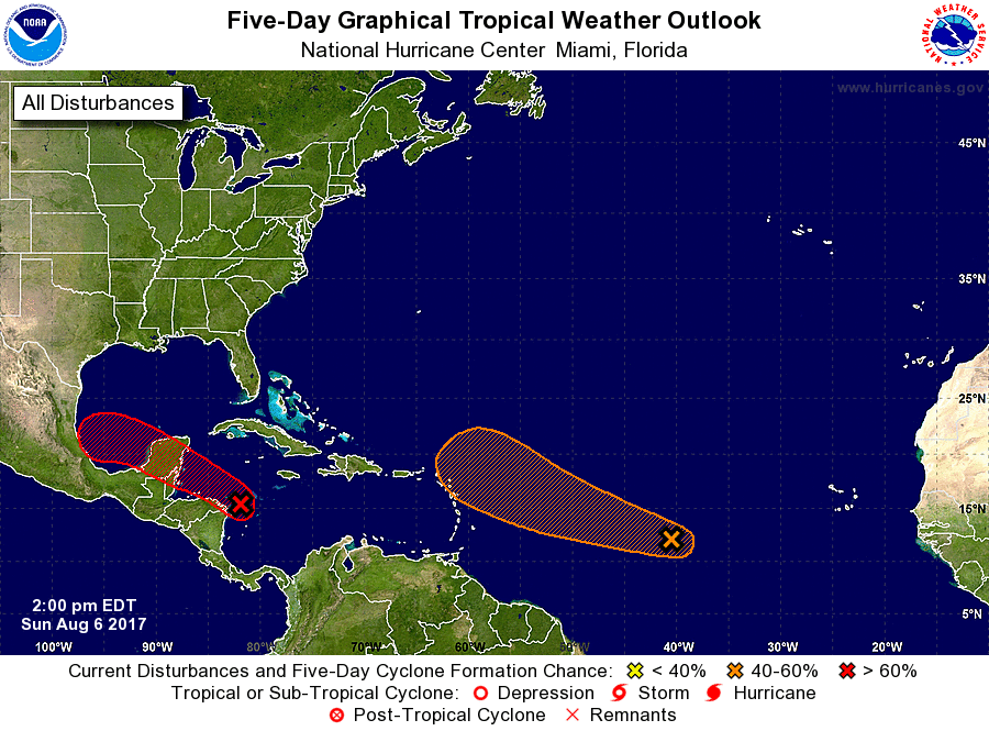 |
Archives
October 2018
Categories |
 RSS Feed
