
|
COMPLEX PATTERNS: Hey y’all, glad to be writing another blog post! We have a really uncertain few days ahead of us and this is the perfect opportunity to write about some of the weather North Texas will experience in the coming days. One of my favorite parts about winter in Texas is how multiple kinds of weather can occur, often on the same day, throughout the winter. This notion definitely stays true to the time ahead of us as well and leads many of us to ask: what will happen with the upcoming weather pattern? SHORT RANGE: Thursday brings the persistence of a sunny, seasonally warm day with plentiful amounts of blue skies and above average temperatures. However, there will be a noticeable change in winds, with gusts up to 20 miles per hour headed northward. These winds are a sign of the change in the weather pattern North Texas will be seeing. So, while the day will continue to be warm like most of the days this week have been, look for some noticeable breezes and the potential for a few clouds in the evening. Nightfall sees a typical drop in surface temperature, but it won’t be as wild as the temperature swings in the past few days (places like Waco saw a near 50 degree difference between the morning low and the daily maximum high on Wednesday) due to the increase in moisture from the active upper-level jet stream and a detached low pressure system. Rain chances increase as the night continues due to high levels of ascent, which should tap into the active jet and move eastward as Friday morning progresses. 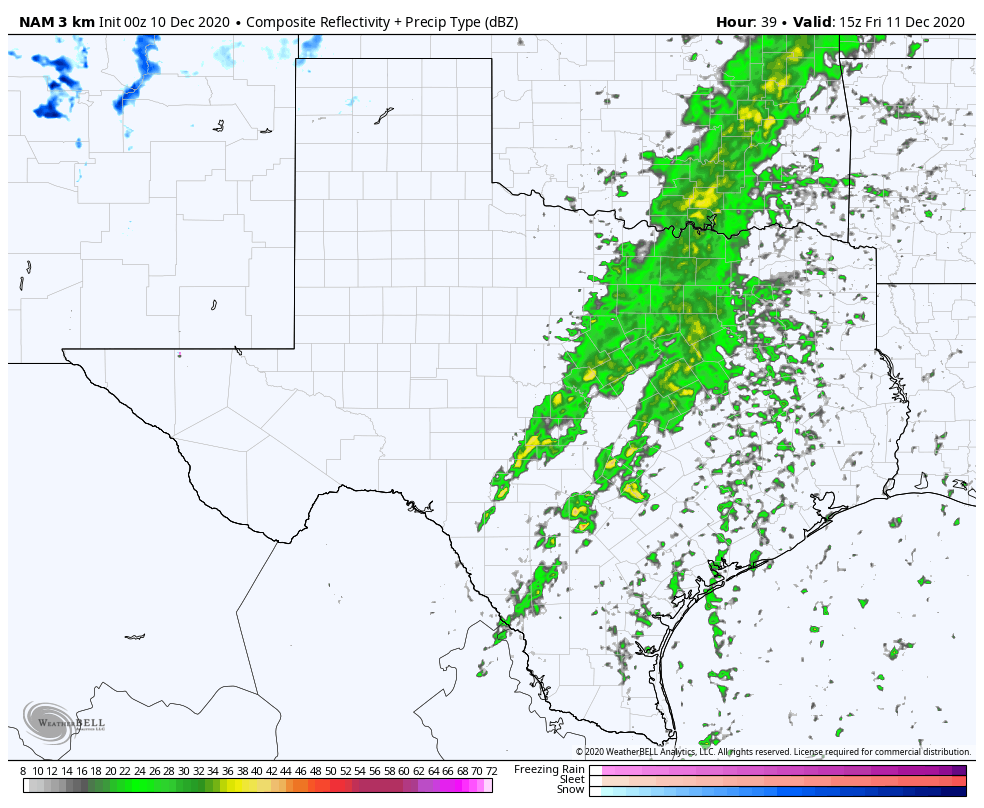 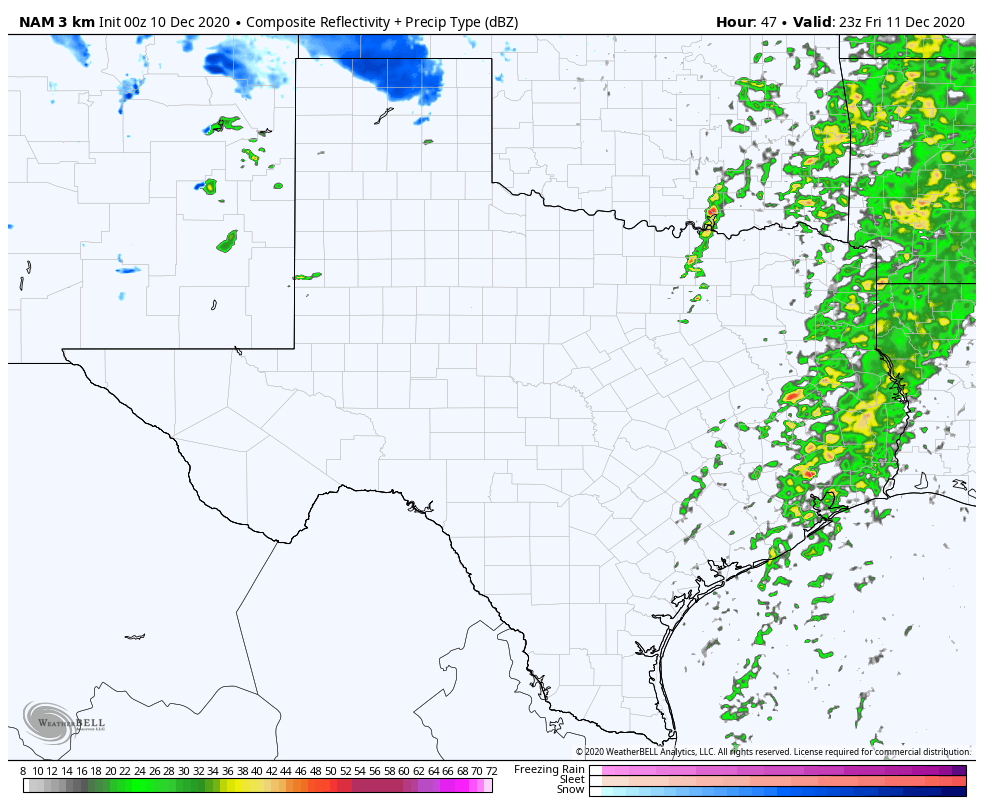 The 00z NAM showing model predictions for rainfall at 9 am and 5 pm on Friday. FRIDAY’S STORM POTENTIAL: As models have slowed the progression of the cold front over the past few runs, in addition to the new high resolution mesoscale model guidance, it has increased the potential for severe weather east of the metroplex midday Friday. While moisture is set to move out eastward midday as the front passes through DFW, ahead of the front in portions of NETX, the potential for lightning and thunder is considerable but still unknown. There is NO risk for tornadoes or even hail, but there is a chance for some lightning strikes as the afternoon begins. In addition, some model guidance supports pop up thunderstorms for DFW in the evening as well, with the potential for a squall line to develop behind the front. As the afternoon turns into evening, the potential for scattered thunderstorms increases. Strong storms are improbable but not impossible east of the metroplex. The new pattern, as a result of the upper level low, will bring much cooler and more seasonal weather with highs on Saturday struggling to break out of the 50s, even with clearer skies. 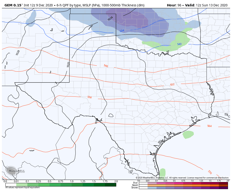 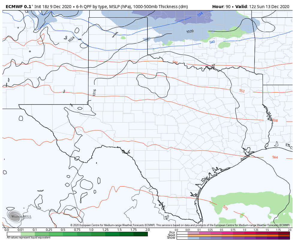 The difference between the Euro and Canadian model for potential weather on Sunday. Note the placement of the blue line—that’s upper level freezing line and indicates that the Canadian Model is showing a lower ULL than the Euro. FUTURE UNCERTAINTIES: I’ll admit, I don’t know what’s going to happen for Sunday. A fairly potent shortwave will move into the southern plains overnight Saturday into Sunday. While temperatures will decrease as a result, it’s more of a strengthening of the effects of the initial front on Friday, rather than a separate front. However, coupled with this shortwave is another upper level low that is capable of producing moisture and increases the uncertainty of the forecast. The uncertainty of the moisture potential and severe storm placement as a result of the speed and strength of the front on Friday also impact the significance of the shortwave over the weekend. Shortwaves like this are very hard to track from even a couple days out, meaning the placement of the low is extremely uncertain as of now and can vary by even a hundred miles. A low tracking upper level low moving through central Texas is much more favorable than a higher tracking upper level low that moves across the red river, because the temperatures that produce wintry mix or even snow are going to be found North of the low. The presence of the initial front on Friday makes this even more complex because a small change in timing or variance of temperatures by even two degrees could massively change the placement of the trough. In general, the global models are showing almost unanimous agreement on snow in Oklahoma and rain in Texas. So, as a result of the massive uncertainties associated with the complex, double upper level low setup, and the lack of high resolution guidance due to the proximity from the event, we are going on the conservative route and showing temperatures in the upper 30s overnight Saturday and in the mid 40s for Sunday. 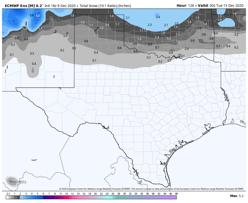 Latest Euro Ensemble Mean indicates North Texas snowfall isn’t out of the realm of possibilities. A wintry mix is, however, possible for the red river basin, given high moisture aloft. lt can’t be ruled out for DFW at this time, however, it remains unlikely given current model guidance. We will know more in the upcoming days.
For now, stay safe, stay warm, and stay weather aware! -Colin Welty Hello everyone! We have a busy meteorological week approaching North Texas with many variables that could range from typical fall days to potential winter weather. There are a lot of potential outcomes that could take place and I’ll be discussing them in this blog update! WEEKEND UPDATE: A relatively mild weekend has been in play for much of North Texas, with highs in the upper 50s for Saturday and approaching the mid 70s for Sunday. It’ll be an absolutely gorgeous weekend for everyone to spend outside and take advantage of before the real fun begins on Monday. 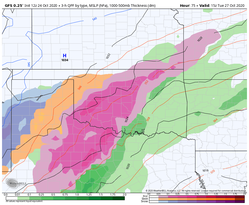 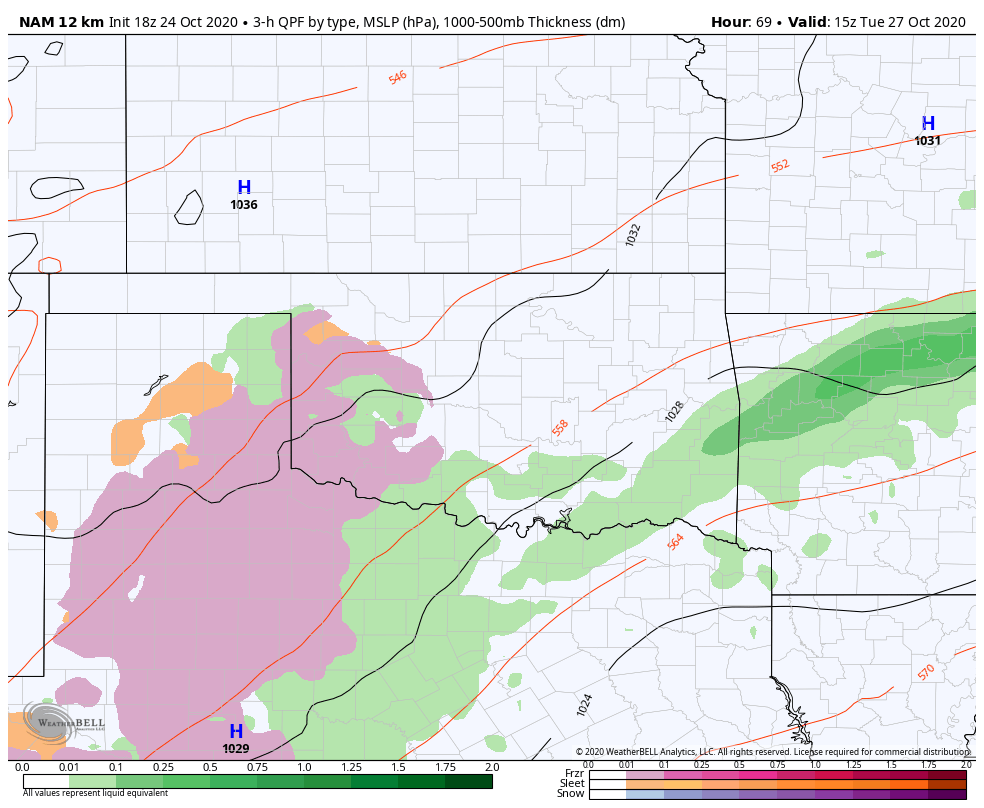 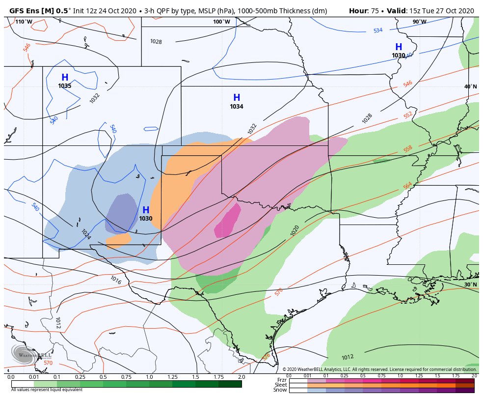 COLD RAIN CAPITAL OF THE WORLD:
As rain moves in overnight Sunday, it’ll be a glimpse of the week ahead for North Texas. Rain will be widespread as a result of a low pressure system with convergence tapping into gulf moisture, keeping temperatures in the 50s for most of the region. However, a high pressure arctic front will move in overnight Monday and will significantly drop temperatures and close off the low pressure system, providing us with plenty of moisture to tap into. While there had been about a weeks worth of models entertaining a potential freeze for DFW and other areas, with sleet and freezing rain looking likely, short range models have now started to roll back the strength of the front. There is considerable disagreement between the ensemble models, who show frontogensis with freezing rain and sleet, and the short range models who are running 5 degrees warmer, making it more and more likely that most of North Texas will see a cold rain on Tuesday and Wednesday with lows in the low 40s to upper 30s. Wind chills are forecasted to be in the low 30s Wednesday morning, which means it’s definitely time to use that winter coat! Parts of the panhandle and WTX are likely to see snow and ice and it’s possible certain parts of NTX see some sleet or freezing rain as well. Oklahoma, especially the panhandle and Western Oklahoma, could also see some significant ice with some models showing up to an inch of accumulation from a freezing rain and sleet mix. However, I am siding with the guidance of the NAM, as it has been the king of winter storms the past few winters, especially given the Euro’s inability to handle certain arctic fronts and the GFS’s inherent cold bias. The addition of a TD in the gulf is further complicating the situation as the influence of that low could force the low across texas to close off further south, allowing the high pressure air mass to travel further south as well, but it’s too early to know how that will play out. So, while a winter wonderland is not entirely off the table, it’s looking likely that North Texas will maintain its standing as the cold rain capital of the world with multiple days of cold rain. While no one should expect to see anything wintry this week, If you see any sort of winter precipitation make sure to tag us in your photos and use #ApexStorm! WHAT DOES THE FUTURE HOLD? After Wednesday, the moisture is set to clear out with pretty mild temperatures occurring throughout the following days. The highs will creep up into the high 60s by the weekend, with clear skies for Halloween night on Saturday! Not too many chances for precipitation in the near future, but there won’t be any record breaking heat either. Keep your eyes out for this upcoming cold front as even 2 degrees colder could massively change the game for winter precipitation. Models have a tendency to underperform, as shown by the cold front Friday morning, and the complicated setup with both arctic air and tropical storms potentially interacting makes this particular forecast extremely difficult to accurately predict, so make sure to stay aware of what could happen in your area. Stay dry, stay warm, and stay weather aware! -Colin Welty BLOG UPDATE:
Hey guys! It’s Colin. I apologize for not having consistent blogs (or getting them out on Saturday) as I’ve been thrown into the college gauntlet as of late and found myself studying the weather more than writing about it. It’s also been different being outside of North Texas, so it’s been a little more difficult to follow the weather. That being said, I won’t be backing down from the challenge! RAINY START TO THE WEEK AHEAD: Consistent rain is set to plague North Texas throughout the beginning portion of this week. Outer bands of Beta with excess moisture have brought light rain to our area as we transition into the fall season with temperatures in the mid 60s and low 70s through Tuesday. None of these showers are associated with severe storms as there isn’t instability present to cause any threat of lightning, thunder, or severe weather. It’s a typical fall rain that provides a nice relief from the rather dry weather from the past week. REST OF THE WEEK: The rain will clear out by Wednesday and temperatures will rise to the 80s by Friday, with highs in the upper 80s over the weekend. It should be a wonderful weekend, possibly one of the final “hot” weekends of the year (though, to be fair, the 80’s aren’t anywhere near “hot” to me anymore). The weather pattern will resume the relatively monotonous cloudless days with average temperatures as we look towards October for our eventual shift to colder weather. Stay safe, stay active, stay weather aware! -Colin Welty  END OF THE METEOROLOGICAL SUMMER:
After a relatively lackluster August, the weather decided to end meteorological summer with a bang. Saturday was an exclamation of every phenomenon we’ve been experiencing—a record breaking day of heat for DFW with heat indices upwards of 115 degrees that culminated in an over-performing cluster of storms all across North Texas, mirroring the scattered thunderstorms simultaneously popping up all across Oklahoma and Arkansas. All of the rain yesterday came at the hands of a weaker shortwave—with another front looming on the horizon, what does this indicate for North Texas next week? MONDAY SHORTWAVES: Sunday continued to be relatively precipitation free, with low chances in the evening as typical destabilization occurs (although, formation of any storms would be extremely limited as the complex of storms that moved throughout the region yesterday ate up most of the moisture). Temperatures will continue to be hot with the potential for Dallas to get to triple digits again Monday. However, during the day Monday, two westerly shortwaves are projected to move in, bringing with it the chance for more severe storms. Coverage for the storms is supposed to be greater and stronger among Southern Oklahoma and along the red river in the middle of the day, but as the day progresses, parts of North Texas could be subject to severe thunderstorms if the timing of the storms allow. Storms could be accompanied by strong winds of up to 60 mph and there is a low, but nonzero risk of small hail. DFW has been placed just south of the slight risk area but that could change as the day continues. TUESDAY FRONT: A large front is scheduled to move into North Texas on Tuesday afternoon that will also bring considerable rain and severe storm chances. Localized amounts of 2-4 inches are possible between the Red River and the northern part of the metroplex, with the severe chance moving southeast as the day progresses. There is a threat for severe storms capable of producing hail and damaging winds, similar to Monday. A moderate risk is in effect for much of North Texas for Tuesday and it’s possible that all of the metroplex is upgraded to slight eventually as there is a strong large-scale ascent. Highs are projected to be in the 80s and there aren’t any chances for tornadoes at this point in time, however, I would urge anyone to continue to stay updated with their local weather affiliates and the NWS/SPC to stay weather aware. THE REST OF THE WEEK: Rainfall chances continue to exist throughout the week, with heavy rainfall forecasted for Wednesday as the shortwave moves out of Texas. Models currently indicate the potential for flash flooding as we see localized pockets of heavy rain around North Texas. Small chances of rain exist for Friday as well if the storms reach far enough south. In good news, however, temperatures will remain much lower throughout the rest of the week following the front, with highs in the upper 80s and lower 90s for the foreseeable future. It will be a welcome break from the onslaught of heat from the last few days. There is even talk of a further cold front after labor day weekend, though it is entirely too far out to legitimize anything. Stay dry, stay cool, and stay weather aware! -Colin Welty After multiple rounds of showers and t-storms last week, this weekend has been fairly dry and pleasant. A couple chances of showers and storms exists this week. Details below...
First off, a weak cold front will slide through North Texas tonight. A few isolated showers or even a t-storm is possible, but coverage will remain pretty low. Most will be dry. As flow aloft favors some storm chances Tuesday morning, limited moisture behind the boundary should keep storms at a minimum Tuesday morning. However, widely scattered showers and a few fumbles of thunder will still be possible as moisture tries to return. Tuesday afternoon will be mainly dry, with highs in the low 90s. A greater storm threat arrives Tuesday night with increased moisture content. NW flow aloft favors a storm complex to dive south out of Oklahoma Tuesday night into early Wednesday. Gusty winds, brief heavy rain, and frequent lightning will be the primary risks. Some small hail also isn't ruled out in the stronger storms. About 20-40% of us see showers and storms. A similar set up will follow late Wednesday night, but should weaken before reaching North Texas. Still, a few showers and storms are possible especially in northeast Texas. Next weekend will be mostly dry and warm with highs in the middle 90s. Logan Shipley WELCOME TO AUGUST!
Hello everyone! I hope everyone has been enjoying the relatively cool weather that we’ve experienced with the cold front that moved in last week. While our neighbors in South Texas just capped off a relatively warm July, we in North Texas experienced a July that was around seasonally average. We had slightly above normal temperatures and around average rainfall as well, making it a forgettable but needed Konya of weather. The more we can avoid record setting heat the better. That being said, we still have another month left in meteorological summer which means there is still plenty of heat left for us. I’ll give you guys a run down of what to expect in this first week of August. RETURN TO SUMMER HEAT: We are relatively lucky to be starting August in the low to mid 90s over this weekend. It’s not unusual for most of North Texas to be experiencing a plethora of triple digit degree days. While 2020 has given us our fair share of less than ideal circumstances, Mother Nature has at least been looking out for us by keeping us relatively seasonal through the summer so far. That being said, temperatures are supposed to climb into the high 90s by the end of the week (with a potential to reach 100 on Friday) and it will feel a lot more like August outside. Another subtle change will be the overall dryness of our upcoming weather pattern. Early outlooks suggest August will stay relatively seasonal, with the potential for heat outbreaks but lacking the moisture we have become accustomed to this year thus far. Straying from the wet weather experienced last week, North Texas won’t experience much, if any precipitation this next week as we are dryslotted with a ridge over us and Hurricane Isaias siphoning off moisture to our east. Tropical storms play an integral part into the complex atmospheric dynamics during the summer and the strengthening or weakening of a tropical system is able to completely change precipitation hundreds of miles away. While Isaias isn’t playing a significant role in our weather at the moment, it’s still interesting to see how tropical systems can affect areas that are far away. This blog post is relatively short just because there’s not too much to talk about unfortunately. However, it’s imperative that everyone continue to hydrate, socially distance, and wear A MASK! Stay hydrated, stay cool, and stay weather aware! -Colin Welty Hey guys! Shorter midweek post ahead.
The heat is unrelenting. We are seeing yet another day in the high 90s and it looks like this heat spell will continue for the foreseeable future. A few weekday updates are ahead. THURSDAY: Expect a high of around 99 today with a heat index of around 105. It will continue to be sweaty weather so continue to hydrate and stay cool. Overnight it’ll reach a low of around 80 degrees, which is still quite warm for a low so make sure to hydrate even if it’s dark outside. FRIDAY: A high of around 98 with another heat index around 105. Humidity will be slightly less than Thursday but not noticeably. The low will hopefully dip below the 80s into the high 70s overnight. Look forward to future updates and sorry for the lack of info! It’s been a relatively informationless week. Stay cool! -Colin Welty  HOT HOT HOT:
Hot weather has blanketed the North Texas area as of late with the sun baking down upon us. Many of us are experiencing our first triple digit days today—many in West Texas are seeing near record heat as well. Somehow, as of writing this, DFW has yet to hit 100 this year but that will definitely change with our hot start to this week. Many places are also seeing heat advisories, so it’s imperative that you drink tons of fluids, wear sunscreen, and keep in the shade at all possible times, ESPECIALLY when staying outside for prolonged periods. While this is a great time to be swimming or enjoying your local park, remember that just being near or in water doesn’t keep you hydrated, so please drink water. And, don’t expect these hot temperatures to disappear anytime soon. LOOKING FORWARD: Sunday is sure to be the hottest day of the year so far with Dallas projected to reach 102 degrees. While this pales in comparison to some of the July heat we’ve experienced in years past, it’s sure to be intense and important to stay on top of. Don’t put yourself in a compromised position because you were ill-prepared for that classic Texas summer heat. The good news is we are late experiencing our first stretch of triple degree weather. The bad news is, it’s coming up, and it’s going to be a rough week for weather as there doesn’t look to be much break from the core of this heatwave. The subtropical ridge is moving over our state and positioning itself right in the heart of Texas, bringing us multiple chances at triple degree weather, though parts of Central and West Texas will likely see much worse temperatures than we do. That being said, heat indices of up to 110 degrees are not out of the question. One thing that is looking somewhat plausible is that the adversely high temperatures of our heatwave could be diminished if atmospheric convection (cumulus clouds mainly) appears each afternoon like some models are suggesting. The bulk of our heatwave will occur from Sunday-Tuesday, with temperatures slightly dropping off as the week progresses. There is also a LOW but nonzero chance of some pop up showers tomorrow as well, mainly in the later part of the day, as convective storms from Oklahoma dissipate as they move southward. If the dissipation gets delayed and the storms move more quickly with more moisture than anticipated, then parts of North Texas could be lucky enough to see some brief relief from the grief of heat. However, confidence in this is low. LATE WEEK: There isn’t too much to report here other than the low potential for some scattered showers and storms Wednesday. Expect to continue to see high temperatures and look out for heat advisories. Continue to drink plenty of water and seek the coolness of the A/C whenever possible. It’ll be hot out there in Texas. Stay cool, stay hydrated, and stay weather aware! -Colin Welty QUIET AFTERNOON: As forecast, the radar is very quiet this afternoon. The sky is mostly sunny, and temperatures are in the mid 90s across the area with heat indices well in the triple digits. There are a few showers for the counties to the northeast, but, those will dissipate by sunset.
THE WEEKEND: Get ready for tomorrow and Sunday to be the hottest days of the year. Highs for the weekend will be in the triple digit mark for most places with heat indices in the 105-110°+ range with mostly sunny skies. Despite potential cloud cover Sunday, it will not be sufficient to suppress the continuing heat, so the Heat Advisory has been extended until Sunday evening. Some places that do not see clouds on Sunday will reach Excessive Heat Warning criteria, and an upgrade to that may be warranted. One way or another, prepare for the hottest weekend of the year. NEXT WEEK: Not much change to the weather forecast. Mostly sunny skies, oppressive heat, highs in the low 100s with heat indices in the triple digits, and non-zero rain chances continue. You may see slight fluctuations in temperature, but, you will not feel the difference. TROPICS: Tropical Storm Fay is moving into New Jersey; maximum sustained winds are 60 mph. Flash flood warnings are in effect for the New York City boroughs this afternoon, where heavy rain continues to fall. The remnant circulation will move into Eastern Canada tomorrow. The rest of the Atlantic basin, including the Gulf of Mexico, remains very quiet for now. Keep in mind the peak of the hurricane season comes in August and September. ON THIE DATE IN 2005: Dennis made landfall as a category three hurricane near Navarre Beach. The hurricane had reached Category 4 strength for the third time earlier in the day on July 10 as it approached Florida, attaining its lowest barometric pressure of 27.46?. This ranked Dennis as the strongest hurricane in the Atlantic basin to form before August; however, this record was broken just six days later by Hurricane Emily, which surpassed Dennis and attained Category 5 status. Colin Welty will continue the blog update this weekend. I will be on vacation next week, so, Logan and Colin will hold down the daily blogs next week. Expect MY next blog update on Monday, July 20th... Enjoy the weekend!!! Donovan Neal Owner - ApexStorm RADAR CHECK: As advertised, isolated showers and storms are non-existent across the region this afternoon. The sky is mostly sunny with temperatures in the middle to upper 90s with heat indices well within the triple digits. Temperatures overnight will stay in the upper 70s. TOMORROW THROUGH THE WEEKEND: Unfortunately, tomorrow looks to be the last time with highs in the upper 90s for a few days. Look for a high in the triple digits this weekend as heat levels continue to rise. A Heat Advisory is in effect through Saturday evening, but, I do expect that to get extended. An Excessive Heat Watch may be needed for areas to the south and east of the metroplex. One way or another, it will stay VERY hot across NTX over the forecast period.  NEXT WEEK: Hot, humid weather is the main headline of weather through the course of next week. Basically, what you would expect around here in July. Highs in the upper 90s to triple digits, mostly sunny skies, and a non-zero chance of an isolated shower or storm during the daytime heating process. TROPICS: Looks like Tropical Storm Fay has formed out of the northern banks of the Carolinas. it will move northeast in coming days, hugging the upper Atlantic coast of the U.S. The system is expected to produce locally heavy rainfall that could cause some flash flooding across portions of eastern North Carolina, the coastal mid-Atlantic, and southern New England during the next few days. Gusty winds are also possible along the North Carolina Outer Banks today, and along the mid-Atlantic and southern New England coasts Friday and Saturday. The rest of the Atlantic basin, including the Gulf of Mexico, is very quiet. ON THIS DAY IN 1979: Hurricane Bob was born in the Gulf of Mexico, becoming the first Atlantic Hurricane to be given a male name. Look for the next Texas Weather Blog update at around noon tomorrow.. Have a great night! Donovan Neal Owner - ApexStorm Double-tap to edit.
LAST CHANCE OF RAIN FOR A WHILE: As an upper trough lifts away from the region, so will the daily chances of scattered showers and storms. Some isolated showers will remain possible to the east of 35, but those will, of course, dissipate by sunset. Highs will continue to be in the mid 90s through the afternoon. The average high for DFW is 95°.  TOMORROW THROUGH THE WEEKEND: Tomorrow will be the beginning of many REALLY HOT days that are in store for North Texas. The afternoon highs tomorrow and Friday will reach the upper 90s, with a few 100° readings in some of our western zones. Heat indices will have no problem reaching the 105-110° range, so, a Heat Advisory has been issued for all of North Texas until Saturday at the EARLIEST. I expect most places to observe their first 100° day of the year on Saturday. The average first 100° day for DFW each year is the first of July, so I think it's a good thing that we are a little behind schedule. Regardless, it is going to be very hot for the weekend. NEXT WEEK: The forecast for next week will feature high temperatures well in the century mark and oppressive heat indices. The rain chances will be minuscule to none for the foreseeable future, providing no relief to the classic summertime heat. The upper level ridge will continue to hold through next week, and, combined with sinking subsidence, we will experience the hottest temperatures of the year over the course of next week. Highs each day will be in the 100-105° range with overnight lows in the low 80s. Heat indices will soar into the 105-110°+ range, so the Heat Advisory will likely continue through most, if not all, of next week, with an Excessive Heat Watch or Warning possible. I can not stress enough how important it is to practice heat safety by staying hydrated, mitigating outdoor activities, and protecting family and pets. We are in a global pandemic, so, you shouldn't be outside anyways. Now, more than ever, is a good time to stay indoors. TROPICS: A broad area of low pressure located near the coast of northeastern South Carolina continues to produce a large area of disorganized showers and thunderstorms over the adjacent Atlantic waters and portions of eastern North Carolina. The low is expected to move northeastward near or just offshore of the North Carolina Outer Banks on Thursday, and then turn north-northeastward and move along the mid-Atlantic coast Friday. Environmental conditions are expected to be conducive for development, and a tropical or subtropical cyclone is likely to form within the next day or so. Regardless of development, the system is expected to produce locally heavy rainfall that could cause some flash flooding across portions of eastern North Carolina, the coastal mid-Atlantic, and southern New England during the next few days. Gusty winds are also possible along the North Carolina Outer Banks through Thursday and along the mid-Atlantic and southern New England coasts Friday and Saturday.  The rest of the Atlantic Basin, including the Gulf of Mexico, is quiet.
ON THIS DAY IN 2003: What may be the world’s highest dew point temperature was recorded at Dhahran, Saudi Arabia, in the Persian Gulf. A dew point of 95 degrees was recorded at 3 PM while the air temperature was 108 degrees. The apparent temperature at that time would have been 172 degrees. Look for the next blog update tomorrow at noon.... Have a great night! Donovan Neal Owner - ApexStorm Over the last few days, we've seen several rounds of thunderstorms, some of which have been severe. Another round is expected late this afternoon. Scattered t-storms are ongoing to the west of DFW (as of 2:35pm) with gusty winds and lightning. These will slowly shift east/southeast with time with a few clusters around this evening.  The WPC has issued a discussion for potential of 2-4" of rain this evening for DFW. Some of these storms may also produce some severe weather, primarily as damaging winds. Frequent lightning and small hail will also be possible. A brief break is expected overnight, but activity will pick back up just before daybreak tomorrow. Another round of thunderstorms is likely with gusty winds, heavy rain, and frequent lightning near I/20. One final round of storms is possible tomorrow afternoon, but should be more isolated to scattered in coverage. Severe weather isn't expected.
The ridge will become dominant late week, but a northerly flow aloft may allow for a storm complex to sneak in at some point this weekend east of I/35, but the chances appear low right now. A 600dm ridge at H5 will build back next week, and our first triple digits of the year (possibly highs beyond 105°) look likely with dry weather expected. Logan Shipley HOT, HUMID SUMMER WEATHER: The weather looks pretty routine for the holiday weekend across North Texas with hot, humid days, a partly to mostly cloudy sky, and the risk of scattered, mostly afternoon and evening showers and storms, generally between 12:00 and 9:00PM. Odds of any one spot getting wet is only about 1 in 5 each day. No way of knowing exactly where and when they pop up, due to small scale features that are not foreseeable. But, remember, when thunder roars go indoors... summer storms, as we saw yesterday evening, can be very effective lightning producers.
We project a high today between 95-98°. Then, the high today will stay in the mid 90s for the holiday weekend. NEXT WEEK: Moisture levels will still stay very high, and a broad upper trough develops over the region. We will maintain the chance of "scattered, mostly afternoon and evening showers and storms" for the first half of the week, before the showers thin out Thursday and Friday. Highs will stay in the mid 90s. TROPICS: The Atlantic Basin remains very quiet, and tropical storm formation is not expected for the foreseeable future. The peak of the hurricane season comes in August and September. ON THIS DAY IN 2014: Hurricane Arthur made landfall at 11:15 pm July 3, over Shackleford Banks, between Cape Lookout and Beaufort, at category two strength. It is the earliest hurricane to hit North Carolina in a season since records began in 1851. Widespread power outages were reported throughout coastal eastern North Carolina. Surge flooding up to 4 to 5 feet above normal was observed over the central and northern Outer Banks with portions of NC Highway 12 and U.S. Highway 64 closed in Dare County. The peak wind gust during the storm was 101 mph at Cape Lookout. We are on a holiday schedule, so no weather discussion tomorrow. But Logan Shipley will post fresh forecast notes on Sunday... Enjoy the weekend! Donovan Neal Owner - ApexStorm TYPICAL JULY WEATHER: Overall moisture levels remain the highest they have been in about three years. So, we will continue to roll with a persistent forecast this afternoon through Friday. Partly to mostly cloudy skies, hot, humid, with the chance of isolated, mostly afternoon and evening showers and thunderstorms. Highs will be in the 93-98° range, with heat indices continuing to be in the 105-110° range. As such, a Heat Advisory remains in effect for much of the coverage area today.  FOURTH OF JULY WEEKEND: The main westerly winds aloft (aka jet stream) will remain far to the north, and fairly typical July weather will continue across North Texas through Sunday. Partly to mostly cloudy, hot, and humid, with the chance of isolated to scattered, mostly afternoon and evening showers and thunderstorms. Most of the thunderstorms (not necessarily all) will form around 12:00-8:00PM, and the odds of any one spots getting wet is about one in three. No exact way of knowing where and when they form, you just have to pay attention to radar trends if you have any outdoor activities. Afternoon highs will be in the upper 90s.
NEXT WEEK: No real change in the forecast next week. Hot, humid summer weather will continue with the daily chance of "isolated, mostly afternoon and evening showers and storms". No way of knowing where and when they form in advance. Highs will be in the mid to upper 90s throughout the week. TROPICS: The Atlantic Basin remains quiet, and tropical storm formation is not expected through the weekend. ON THIS DATE IN 2001: In Michigan, frost and freezing temperatures were observed in some locations with Grant dropping to 29 degrees. Muskegon reported their coldest July temperature on record with 39 degrees. Other daily record lows included: Lansing: 38, Muskegon: 39, Flint: 40, Youngstown, Ohio: 40, and Grand Rapids, Michigan: 43 degrees. Look for the next blog update tomorrow at around 5PM.... Enjoy the day! Donovan Neal Owner - ApexStorm HUMID MORNING: With the absence of wind from yesterday, it is a very muggy late June morning across North Texas with dewpoints in the mid 70s to mid 80s range. We note some showers out in Central Texas, but we might see a random afternoon storm or two as the air continues to heat and become unstable. I expect a high in the mid 90s range across the area this afternoon with heat indices well in the triple digits. The average high for DFW on June 30 is 94°. REST OF THE WEEK: Not much change for the rest of the work week. Partly to mostly sunny skies with highs in the upper 90s. Heat indices will once again be well in the triple digits. As such, a Heat Advisory is in effect for much of the North Texas region until at least Wednesday. Keep in mind that this can be extended for a couple more days if need be.  FOURTH OF JULY WEEKEND: High PWAT (precipitable water) values will cover much of North and Central Texas on Saturday, so we will mention mostly cloudy skies with the chance of isolated to scattered afternoon and evening showers and storms. Most of them (not all) will come from around noon to 9:00 PM, and the odds of any one spot getting wet is about one in five right now. There is no way of knowing in advance where and when they form. You just have to watch the radar, especially if you have outdoor festivities planned. Remember, when thunder roars, go indoors. We have had one lightning fatality so far this year, and that is one too many. Highs will be in the mid 90s for the weekend.
NEXT WEEK: We will continue to roll with a persistent forecast of a mostly to partly sunny sky with highs in the mid 90s and very hot heat indices. TROPICS: A trough of low pressure is located off the coast of North Carolina. Significant development of this system is not anticipated while it moves generally northeastward, away from the east coast of the United States and merges with a frontal boundary. The rest of the Atlantic basin is very quiet. ON THIS DAY IN 1912: An estimated F4 tornado ripped through Regina, Saskatchewan, Canada on this day. The storm became the deadliest tornado in Canada’s history as it killed 28 people along a rare, 18.5-mile track from south to north. Look for the next weather discussion and blog update at around noon tomorrow... Enjoy the rest of the day! Donovan Neal Owner - ApexStorm SUMMERTIME WEATHER: The weather pattern looks typical for late June/early July here in North Texas this week. The main jet stream remains well to the north of the state, and we are in a very humid airmass. Each day this week, we expect a partly to mostly sunny sky, and, as the summer heat and humidity develops today and Tuesday, the air becomes buoyant, thus, opening the door for showers and thunderstorms to develop. In these zones, these showers and storms tend to have a random nature to them in the summer time, and most of them form between the hours of 12:00 PM through 9:00 PM. The odds of any one spot getting wet today and tomorrow is about one in ten, and the heavier storms may be strong to severe with damaging winds and hail. 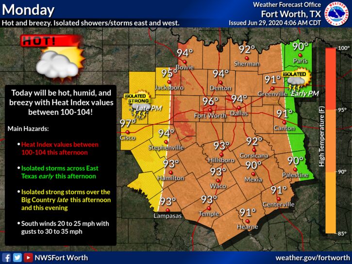 Hour by hour changes in the placement of showers and storms are determined by small scale weather features that are impossible to pinpoint well in advance. Otherwise, temperatures will be at around seasonal averages this week, around the mid 90s with the heat indices well in the triple digits.
HOLIDAY WEEKEND: Not much change. Look for partly sunny hot, humid days with highs in the mid 90s with heat indices in the triple digits. Chance of an isolated storm on Saturday. NEXT WEEK: Annnddddd, the same pattern rolls along. The same forecast ensues with hot, muggy days with highs in the low to mid 90s with heat indices in the triple digits. TROPICS: Shower and thunderstorm activity associated with a tropical wave located over the central tropical Atlantic has increased during the past few hours. Some slight development of the wave is possible during the next day or so while it moves westward to west-northwestward at around 20 mph. Strong upper-level winds are forecast to inhibit further development by mid-week. And, an area of low pressure is forecast to form off of the southeastern coast of the United States on Tuesday. Some development of this system could then occur later this week as it moves generally northeastward well offshore of the east coast of the United States. The rest of the Atlantic basin is quiet. ON THIS DAY IN 1998: “The Corn Belt Derecho of 1998” in the following states NE, IA, IL, IN, KY. A derecho which originated in far southeast South Dakota moved across Illinois during the afternoon and evening and continued as far east as Ohio the next morning. Every county in central Illinois sustained some damage, as these severe thunderstorms passed. Winds gusted in the 60 to 80 mph range, with some localized microbursts producing winds more than 100 mph. Significant damage occurred in the microburst areas, including the towns of Morton, McLean, LeRoy, and Tolono. In Tolono, 22 cars of a southbound 101-car Illinois Central freight train were blown off the tracks. It was unknown how many vehicles were picked up by the wind, but 16 cars were turned over, and another six derailed but remained upright. The train was en route to Centralia from Chicago with a load of mixed freight, including plastic pellets and meal. The freight cars empty weighed about 60,000 pounds, while a full one weighs about 260,000 pounds. Overall, 12 people were injured, and damage was estimated at around $16 million. Look for the next blog update at around noon tomorrow... Enjoy the day! Donovan Neal Owner - ApexStorm 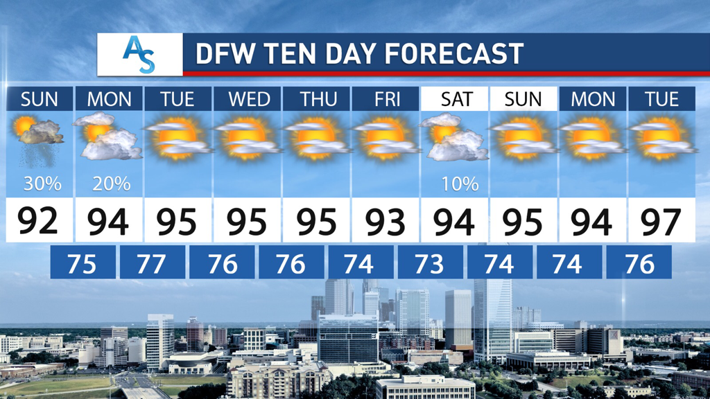 SAHARAN DUST:
Hope everyone has been enjoying the last few days of dryness! As you all know, Saharan Dust has made its way to North Texas and briefly impacted our air quality. The haze in the sky is attributed to the dust and will disappear within the next 24 hours. It has made for some really pretty sunsets as a plus, however. What is there to look forward to after the dust? STORM CHANCES: We will have some low storm chances as a result of increased northwest flow aloft potentially allowing for some complexes to develop on Sunday/Monday. These storms will be scattered if they develop and with even a potential severe risk if the cap breaks quickly enough on Sunday with the weak disturbance. The potential is low but nonzero. In addition, currently a chance exists for Thursday as well but there is less confidence for later in the week while we wait for the conditions to become more favorite and understood for the ability to produce these complexes. OTHERWISE: Expect this week to be a typical June week. There will be plenty of temperatures in the 90s but we aren’t expected to reach triple digits in the next week. It will likely be quite humid, however, so be mindful of heat indices that are stronger than normal. This pattern is capable of producing rain as well as producing sunny, humid weather. Not too much to really talk about, but there will likely be chances for people to enjoy the outdoors and hit the local pools. Stay dry, stay cool, and stay weather aware! -Colin Welty HUMID JUNE DAYS: Very moist air will hang over North Texas for the foreseeable future, and we will still mention the chance of isolated to widely scattered showers and storms, mainly during the afternoon and evening hours today. Most of them (not necessarily all) will come at around the noon to 9:00 PM timeframe, and the chances of any one spot getting wet is about one in five. With a Bermuda High in place across the southeast, the Plains will experience a tightening gradient. Meaning, warm and breezy weather conditions will continue through the weekend, and any showers and storms will become more isolated. Saturday should be mostly dry, but isolated showers associated with a weak shortwave is possible on Sunday. Otherwise, the weekend should be mostly dry with afternoon highs in the 90-93° range.
NEXT WEEK: Not much change. The main jet stream should remain well to the north of Texas, so, very humid air stays in place. Look for mostly sunny days with highs somewhere in the 90-95° range and increasing heat indices by Tuesday. An overhead northwest flow could develop by midweek, which could open the door to complexes of showers and storms both Thursday and next Friday. Due to natural uncertainties, we will only mention a small chance of rain during these days. TROPICS: The Atlantic Basin remains very quiet, and tropical storm formation is not expected through next week. DUSTY DAYS: THE SAL (Saharan Air Layer) covers North Texas today. The dust, with origins from the African continent, is mostly several thousand feet off the ground, and will give the sky a hazy appearance. There can be some reduction in air quality, but it will not impact most people. We had some glorious sunsets last night over North Texas, and expect the same this evening due to the scattering of the sunlight. The SAL moves into the Southern US just about every year. This is nothing unusual, and no “emergency” despite some of the media hysteria. ON THIS DATE IN 1957: Hurricane Audrey was in the western Gulf of Mexico; a category three storm. Landfall would come the following day, June 27, between the mouth of the Sabine River and Cameron, Louisiana,. It would go on to cause unprecedented destruction across the region. Prior to making landfall, Audrey severely disrupted offshore drilling operations in the Gulf of Mexico. Damages from offshore oil facilities alone was estimated at $16 million. Damage from the surge alone extended 25 miles inland. The rough seas killed nine people offshore after capsizing the boat they were in. Further inland in Louisiana, the storm spawned two tornadoes, causing additional damage. Audrey also dropped heavy rainfall, peaking at 10.63″ near Basile. In Louisiana and Texas, where Audrey first impacted, the damage toll was $128 million. The total death toll was 416. Look for the next blog update by Colin Welty tomorrow... Enjoy the day and have a great weekend! Donovan Neal Owner - ApexStorm RADAR CHECK: The weather radar is very quiet across the North Texas region this morning. There is convection near the Houston area with Flash Flood Warnings in effect to the west of Houston. That rain will move north this morning, which will initiate the chance of isolated, mostly afternoon and evening showers and storms for areas to the south of I-20 and to the east of I-35. Otherwise, the sky is mostly sunny with temperatures in the upper 70s to low 80s. The high will be just at the 90° mark for most communities; the average high for DFW on June 25 is 93°. FRIDAY AND THE WEEKEND: For those to the southeast of the metroplex, showers to the south and east will eventually thin out with time, but, we will still need to maintain the chance of scattered showers and storms during the afternoon and evening hours. Most of them (not all of them), will come from around 12:00 to 9:00 PM, and the odds of any one spot getting wet is about one in five. No way of knowing exactly where and when the storms form. You just have to keep track of radar trends. Highs will generally be in the 90-93° range. NEXT WEEK: Not much change in the weather is expected through next week. Partly cloudy, hot, humid with highs in the low to mid 90s. Dewpoints will continue to be in the 70s, so we will have to mention increasing heat indices. Many places will see heat indices in the 100-105° range by Tuesday or Wednesday. 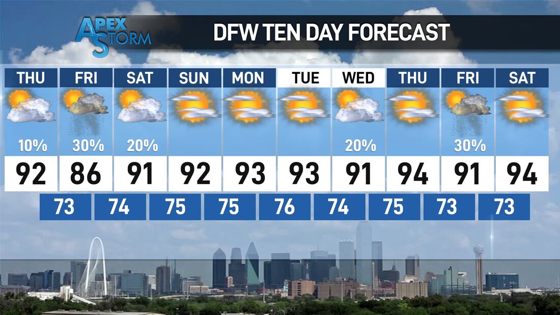 TROPICS: The Atlantic Basin remains very quiet, and tropical storm formation is not expected over the weekend.
AFRICAN DUST: The SAL (Saharan Air Layer) has moved up into the Gulf Coast region this morning, and will cover more of North Texas tomorrow and over the weekend. This is dry, dusty air that originated over the African continent a couple of weeks ago, and can make the sky rather hazy. There will some reduction in air quality, but it won’t bother most people. The dust will scatter sunlight, bring potential for vivid sunrises and sunsets. This is not unusual, and it happens just about every summer. The size of this SAL is larger than usual, however. ON THIS DAY IN 1967: Three, F3 tornadoes crossed the Netherlands on this day. The first tornado touched down at 4:17 PM in Oostmalle. This storm destroyed the church and the center of the village. More than half of the 900 homes in the community were damaged with 135 completely gone. The second tornado touched down near Ulicoten and tracked northward through woodlands area. This storm killed two people at a camping site near Chaam, Netherlands. The third tornado destroyed 50 houses in Tricht, killing five and injuring 32 others. Look for the next blog update at around noon tomorrow... Enjoy the day! Donovan Neal Owner - ApexStorm MOSTLY SUNNY MORNING: We have a decent supply of sunshine over most of the region this late morning, and we have rain falling for a decent area in the southeast. Occasional showers and storms will be possible this afternoon and evening, and should not be a washout.
Highs will be in the upper 80s and low 90s today through Friday in wake of a very weak front stationary over Southern Texas, but it will sure be very moist. The average high for DFW at around this time of the year is 93°. A retreating warm front on Friday should pull enough moisture back into the region to mention the chance of isolated, mostly afternoon and evening showers and storms. The sky will be partly cloudy with highs in the low 90s. THE WEEKEND: As a classic, summertime ridge starts to build over us, we will forecast classic late June weather for the weekend; mostly sunny with highs in the low 90s. Showers will continue thin out Saturday, and should completely thin out on Sunday as thee air becomes drier. NEXT WEEK: Classic late June/early July weather continues. That being said, the increasing concern will be heat index values, starting over Central and East Texas Monday afternoon. Highs will be in the low to mid 90s, but, heat indices will be in the 100-105° range for those areas as a result of dewpoints in the mid to upper 70s. This oppressive heat will make its way to the rest of the North Texas region by Tuesday or Wednesday afternoon. This is the classic summertime weather here in Texas, so get ready for the annual oppressive heat as we head into Independence Day weekend and the middle of summer. HI DOLLY, BYE DOLLY: Tropical Storm Dolly formed yesterday, several hundred miles to the east of the US Coast. It has already been downgraded to a remnant low, and should completely dissipate tomorrow with no threat to land. The rest of the Atlantic Basin is quiet. SAL LAYER: The dry, dusty Saharan Air Layer (SAL) coming off the African continent is moving up into the Gulf Coast region, it will be place across Southern US for a few days giving us potential for some vivid sunrise/sunset views due to the scattering of sunlight. The dry air also means no risk of tropical storms or hurricanes over the Gulf for the next week or so. There could be some reduction in air quality, but most of the dust is several thousand feet aloft and most folks won’t even notice it. It happens just about every summer… nothing unusual. ON THIS DAY IN 1975: An Eastern Airlines Boeing 727 crashed at JFK airport in New York City. 113 of the 124 people on board the aircraft died. Researcher Theodore Fujita studied the incident and discovered that a microburst caused the crash. His research led to improved air safety. The tower never experienced the microburst, which was held back by a sea-breeze front. The plane crashed 2,400 feet short of the runway. Look for the next Texas Weather Blog Update at around noon tomorrow... Enjoy the day! Donovan Neal Owner/Founder - ApexStorm RAINFALL TOTALS: As of 7AM this morning, here are the rainfall totals over the past 24 hours... Arlington 0.46 Corsicana 0.01 Dallas Love Field 0.51 DFW Airport 0.91 Denton 1.95 Fort Worth Alliance 1.44 Fort Worth Meacham 1.46 Longview 0.04 Lufkin T McKinney T Mineral Wells 0.01 Paris 1.10 Terrell 0.07 Wichita Falls Municipal: 2.45 So far, showers and thunderstorms are not materializing as of late afternoon, but that could change within an hour or so. A few isolated supercells could develop along a residual outflow boundary, capable of hail and strong straight-line winds. After midnight, a complex of severe thunderstorms capable of large hail and damaging winds may impact the region after midnight. Heavy rain is also possible. SPC maintains the standard "slight" risk (level 2/5) of severe storms for much of the metroplex through 7AM tomorrow.  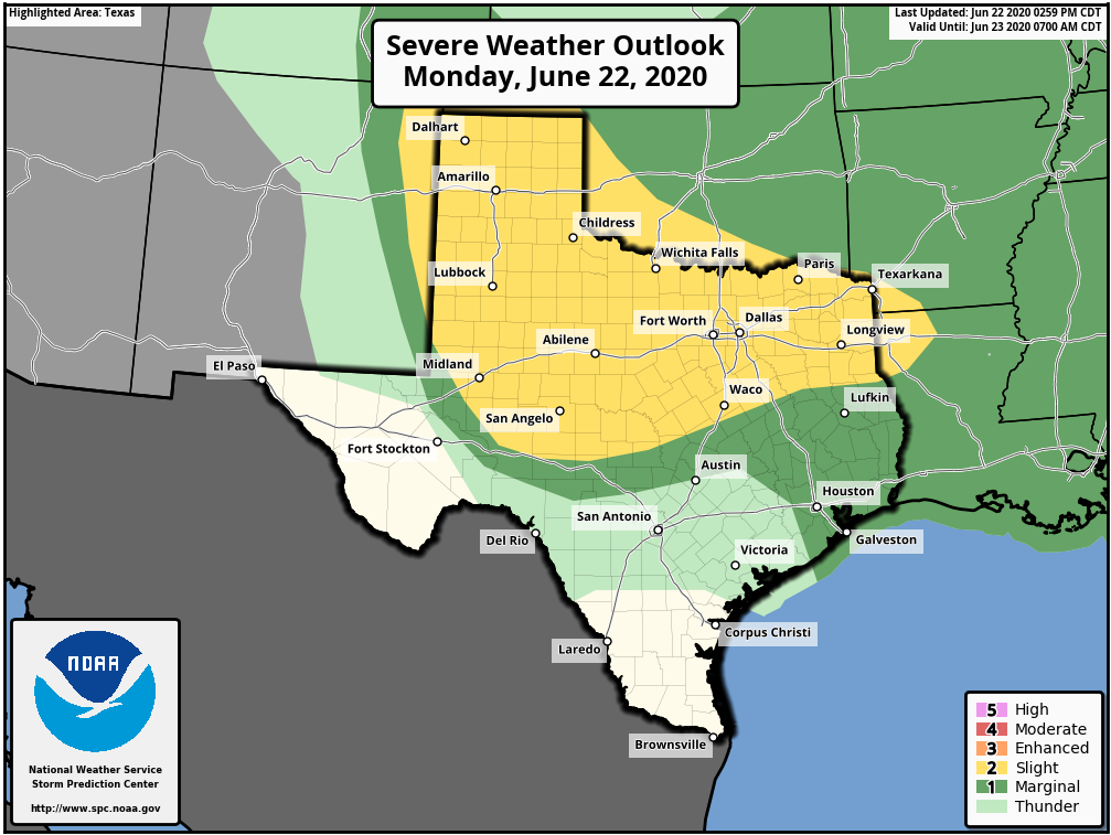 REST OF THE WEEK: An upper trough, combined with deep layer moisture, will keep our weather pattern unsettled through most of the week. Look for more chances of isolated to scattered showers and thunderstorms, mostly in the afternoon to overnight hours. Like tonight, severe storms are possible with wind and hail possible. The sky will be partly to mostly sunny with highs in the upper 80s to low 90s. Showers will be possible Thursday and Wednesday afternoon, but, they will be fewer in number.
THE WEEKEND: Look for a mostly sunny sky with the chance of an isolated shower and storm or two. Highs will stay close to 90° over the weekend. NEXT WEEK: We will stick with the classic summer forecast for much of the week; mostly sunny skies, highs in the 93-95° range. TROPICS: Shower and thunderstorm activity associated with a well-defined low pressure system located about 350 miles southeast of Cape Cod, Massachusetts, has continued to get better organized today, and a subtropical depression has formed this afternoon. The system is expected to move to the east/northeast, staying away from the US at this time. The rest of the Atlantic Basin is quiet. AFRICAN DUST: The SAL (Saharan Air Layer), with origins over the deserts of Africa, is pushing through the Caribbean this morning, and should reach parts of the southern U.S. later this week. This dry, dusty air is transported in high levels of the atmosphere, generally between 5,000 and 20,000 feet, and the main effect is creating very vivid sky scenes at sunrise and sunset due to the scattering of sunlight. The dry air also mitigates any tropical storm formation. There can be a reduction in air quality, but most of the dust is several thousand feet off the ground and is not an issue for most people. And, this is NOT unusual in summer. ON THIS DAY IN 2007: The first officially documented F5 tornado in Canada struck the town of Elie, Manitoba population 500 people. Video of the storm showed a heavy van being whirled through the air. The storm also tossed an almost entire house several hundred yards through the air before it disintegrated. The tornado traveled across the landscape for about 35 minutes covering 3.4 miles and leaving a damage path 984 feet wide. Wind speeds in the tornado were later estimated at 260-316 mph. Fortunately, no fatalities or serious injuries were reported.  SUMMER STORMS:
After weeks of dry, hot, summer weather, much of DFW saw a return to rain on Friday. Some isolated areas got upwards of 5 inches overnight, with most areas getting at least an inch of rain. While we returned to clear skies for the weekend we can expect this new rain trend to continue for the next week. The pattern has shifted from our dry spell and, due to our NW flow, more shortwaves will come this week with rain totals that could exceed 5 inches for parts of North Texas. EARLY WEEK: A low pressure system will move down the Texas Panhandle on Monday and produce a shortwave that will move southwest into DFW producing a MCS which could dump a major amount of rain on Tuesday and Wednesday for North Texas. There are varying model solutions for those two days but it is likely that storms will come in late Tuesday and persist overnight through Wednesday. The European model is extremely aggressive and shows bands capable of producing over 10 inches of rain for parts of Texas and it is unlikely that a solution like that unfolds, but could develop if all the right conditions are in place. I’m leaning towards only 2-3 inches for DFW but it’s important to monitor what will happen as the low pressure system moves over Texas and as the shortwave develops. In addition, temperatures will be, on average, 5-10 degrees cooler than the weeks beforehand, with Tuesday potentially struggling to get past 85 degrees. While this will be accompanied by humid weather, potentially raising the heat index, it’ll hopefully be a nice change for us. LATE WEEK RAIN: Rain is possible for the rest of the week as well with multiple chances for scattered thunderstorms through next weekend. The shortwave coming through early next week is a side effect of the larger trough that will position itself over Texas for the next week, creating favorable conditions with an active southern jet. While it is currently forecasted for Central and Southern Texas to get more rain than North Texas through the end of the week, it’s extremely possible that there is enough rain to push DFW over the average rainfall for the month—a stark contrast from how dry and hot the month started. Temperatures will also stay within the mid to high 80s in the day and 70s overnight, feeling more like August in Hawaii than June in Texas. It’ll be a refreshing change of pace for sure! Stay dry, stay cool, and stay weather aware! -Colin Welty NORTHWEST FLOW ALOFT: Moisture levels will begin to slowly increase today through next week as a northwest flow aloft builds across the South-Central US which will open the door for moisture, resulting in more chances of scattered showers and storms, MCS's, and more clouds. A complex of thunderstorms from Oklahoma and West Texas will gradually weaken and move into portions of North Texas after midnight. Not everyone will see rain, but the greatest chances lie for those closest to the Red River. Otherwise, we project a high in the 91-94 degree range this afternoon with the chance of isolated, mostly afternoon and evening showers and thunderstorms. Another complex of showers and storms will emerge from South Oklahoma and move south overnight on Saturday, arriving to most of the metroplex by daybreak Sunday. Each afternoon will feature highs in the low 90s with a mix of sun and clouds and fair nights. An afternoon shower or two can not be ruled out, but, odds of any one spot getting wet are only 10 percent during the afternoons. NEXT WEEK: Moisture levels continue to be above normal, and we will continue to insert daily chances of "isolated, mostly afternoon and evening showers and storms". Afternoon temperatures each day will be in the low 90s due to cloud cover and showers. Rain distribution will not be even, but many communities have a chance of seeing 1 to 1 1/2 inches during the week.  TROPICS: The Atlantic Basin remains very quiet, and tropical storm formation is not expected through next week. The SAL (Saharan Air Layer) could reach the Southeastern US by next week, setting the stage for vivid sunrises and sunsets, especially along the coast.
ON THIS DAY IN 1972: Hurricane Agnes deluged Pennsylvania and New York with torrential rains resulting in the most costly flood in U.S. history. In the Middle Susquehanna Valley of Pennsylvania, 24 hour rainfall amounts were generally 8 to 12 inches, with up to 19 inches in Schuylkill County. At Wilkes-Barre, the dike was breached, destroying much of the town. Flooding resulted in 117 deaths and $3.1 billion in damage. Look for the next Texas Weather Blog here tomorrow from Colin Welty... Have a great weekend! Donovan Neal Owner - ApexStorm RADAR CHECK: We do have a few showers across South Texas this afternoon, but they are few and far between, as forecast. Most of the state is dry with mostly sunny skies and temperatures in the 90s.  Showers will gradually diminish after sunset, and tonight will be mostly fair with lows in the mid 70s. A weakening MCS will spit out of Oklahoma through the overnight hours, and will eventually make it into at least the Northwest Texas region during the morning. We will introduce the chance of scattered showers and thunderstorms through the morning and afternoon before sunset. Some of the more isolated storms may become strong to borderline severe during the peak of the daytime heating process, so the SPC has issued a "marginal" risk (level 1/5) of severe storms for the western parts of the region. 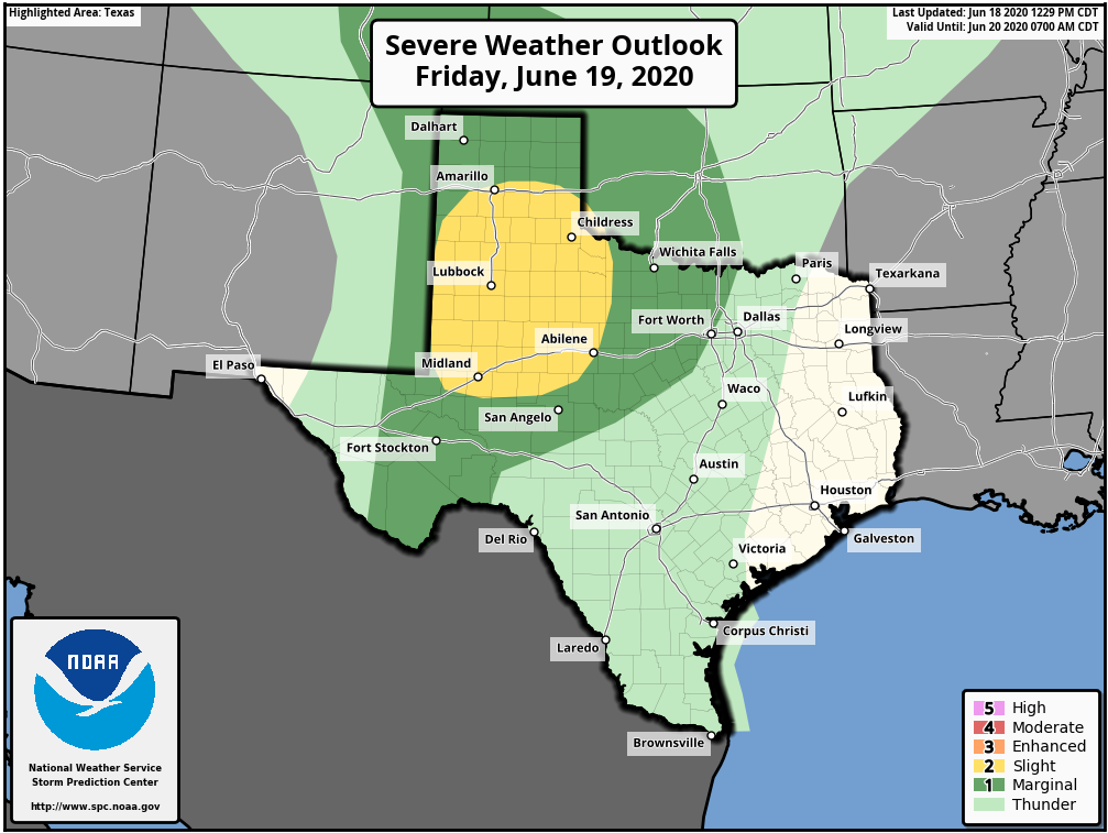 Not everyone will see rain, but, some downpours are possible due to high precipitable water values. Everyone else will be partly sunny through out the day with highs in the low 90s. THE WEEKEND: Another MCS will develop along the Red River through the late morning, and move southeast through the metroplex as it weakens. Through its weakening trend, scattered showers and thunderstorms will be possible during a small window from 11-5PM. The morning will feature partly to mostly sunny skies. Highs in the afternoon will stick to the low 90s. Afternoon showers remain more isolated on Sunday, and highs should continue to be around the low to mid 90s. NEXT WEEK: With the projected northwest flow in the upper pattern, the pattern will remain unsettled with daily chances of "scattered, mostly afternoon and evening showers and storms". If you have lived in North Texas long enough, you should know that there is really no way to predict when or where these storms initiate and linger due to the random, scattered nature of the storms; you just have to make sure to keep an eye on the radar if you are slated to participate in any socially-distant outdoor activities. 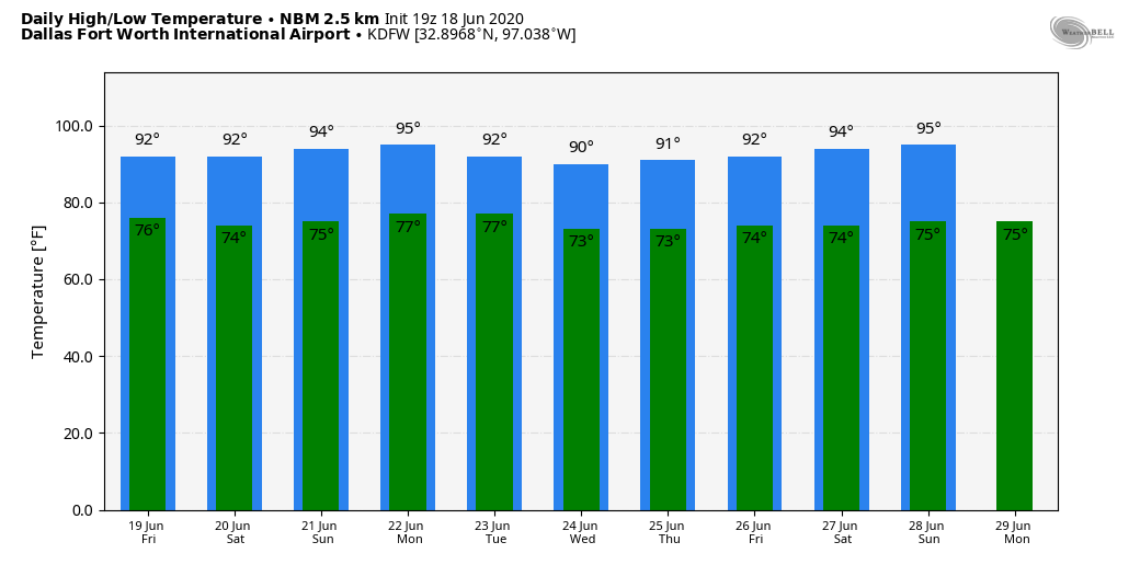 TROPICS: All is quiet in the Atlantic Basin, and tropical storm formation is not expected through the weekend.
ON THIS DAY IN 1989: Unseasonably hot weather prevailed in the southwestern U.S. In Arizona, afternoon highs of 103 degrees at Winslow, 113 degrees at Tucson, and 115 degrees at Phoenix were records for the date. Look for the next Texas Weather Blog before noon tomorrow... Enjoy the evening! Donovan Neal Owner - ApexStorm Here are some late afternoon temperatures across the DFW Metroplex... FW AIRPORT 93 DALLAS LOVE 94 FTW MEACHAM 92 DAL-EXECUTIVE 94 FTW-ALLIANCE 94 FTW-SPINKS 95 ARLINGTON 95 GRAND PRAIRIE 91 ADDISON 93 MESQUITE 93 LANCASTER 93 The average high for June 17 is 92°, so a number of communities around the metroplex are around or just above our seasonal average for this time of the year. The sky is mostly sunny, and storms to the east are few and far between. 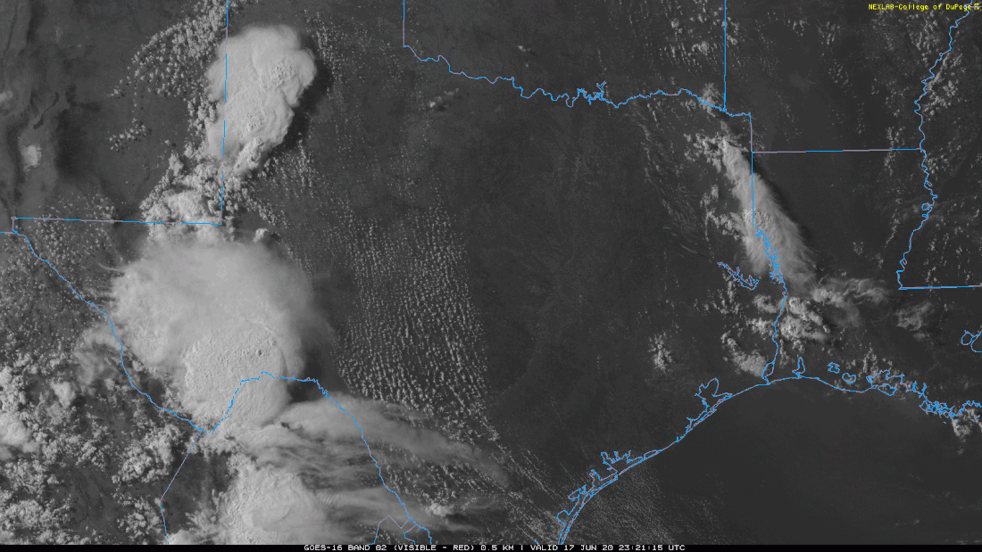 TOMORROW THROUGH THE WEEKEND: The weather will not change much tomorrow. Look for mostly sunny skies with a few widely isolated showers and storms, mainly for our eastern counties. The high will be in the low to mid 90s. Then, on Friday, a mesoscale convective system (MCS) could develop in Oklahoma, and make it to parts of the metroplex as it gradually weakens through the evening and overnight hours. Saturday will feature much of the same boring dry weather. Then, on Sunday, a mid June cold front makes its way to the area, which will subsequently raise our daily chances of scattered, mostly afternoon and evening showers and thunderstorms through at least the beginning of next week. There is a chance that a couple of storms on Sunday could be strong to severe during the peak of daytime heating. Temperatures will stay in the mid 90s with increased humidity. NEXT WEEK: Global models continue to hint the idea of increased coverage of scattered showers and thunderstorms each day as the air becomes more unstable, and the humidity continues to rise. Highs will be in the low to mid 90s with a mix of sun and clouds each day. 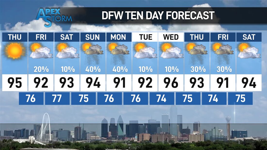 TROPICS: Dry, dusty air from the African deserts will move across the Atlantic in the coming days, eventually reaching the Southeast US by next week. This can set the stage for very vivid sun rises and sunsets, and it also means that no tropical storm formation is expected for the foreseeable future. The peak months of the Atlantic Hurricane Season is usually in August and September. The next named storm will be "Dolly".
ON THIS DAY IN 1882: A tornado traveled more than 200 miles across the state of Iowa killing 130 persons. The tornado traveled at nearly 60 mph and touched down about 90 miles west of Grinnell, struck the town and college around sunset, killing 60, and caused more than half a million dollars damage. |
Archives
March 2023
Categories |
 RSS Feed
