
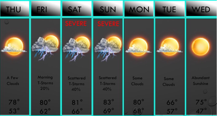
 We have a few chances of storms returning this weekend, so let's dig in and talk about what's going to go down! First of all, there's a very slight chance that a few storms may develop northeast of the DFW area Friday morning along a weak cold front. This will have no impact on temperatures on Friday, just a wind shift. We should see mainly sunny skies heading into the afternoon hours with scattered cumulus clouds overhead. No storms are anticipated in the DFW area at this time. A disturbance will draw in some moisture from the Gulf of Mexico late Friday night, and with lift, scattered thunderstorms will develop during the daytime hours on Saturday. The latest European and American model both have a cluster of storms bringing strong winds and hail to the Dallas/Fort Worth area during the evening hours on Saturday. Below is the risk area map for severe weather on Saturday. 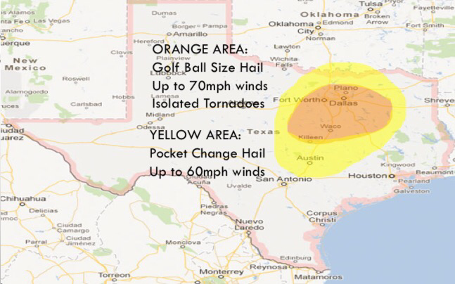 A few storms may be capable of quarter to golf ball size hail, 60-70mph wind gusts, and possibly a weak tornado late Saturday afternoon into the evening hours. The highest risk will be in the orange shaded area, which will favor areas along and south of D/FW towards the Waco area. T-Storms will also produce heavy rain and lightning. Any remaining storms will linger into Sunday morning mainly north of D/FW. By Sunday midday, isolated storms may develop in North Texas. These will pose a high wind and hail risk in the D/FW area. Then we will be watching a surface low and a dryline/cold front combination during the late afternoon and evening hours. As this approaches our western counties by mid afternoon, a cluster of strong to severe thunderstorms will develop. This will congeal into a line by evening with large hail, straight line winds, and a brief tornado threat in the DFW metroplex. Below is the severe map for Sunday afternoon. 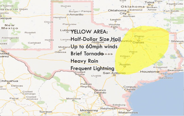 PWATS will be higher during the evening hours on Sunday, so heavy rain will also be a threat during the afternoon/evening. All storms will exit the area late Sunday night and we will clear out on Monday and all of next week looks mainly dry and pleasant, but storm chances look to return next Thursday and Friday. It is way to early to predict any severe weather.
-Jonathan Williams |
AuthorWrite something about yourself. No need to be fancy, just an overview. Archives
March 2021
Categories |
 RSS Feed
