
|
One thing you must understand is that we are in the midst of severe weather season in Texas, so multi-day severe weather threats are common in North Texas at around this time of the year. We will be dry tomorrow, but parts of the east will have a significant severe weather risk on their hands tomorrow. For Today - This is the day we were most concerned and also the most uncertain about. All of the instability, lift, and shear is there to quickly turn storms quite severe this evening, but the main concern is moisture near the surface by the evening hours. The Storm Prediction Center has brought back the standard "slight" risk of severe storms to include all of the DFW Metro areas to the north of the I-35E/I-35W joint. 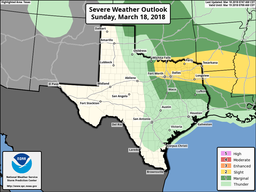 We do note that the SPC has included a 15% hatch area in their hail outlook. Which means that there is at least a 15% chance of seeing hail that is greater than two inches in diameter within 25 miles of a given point within that region. 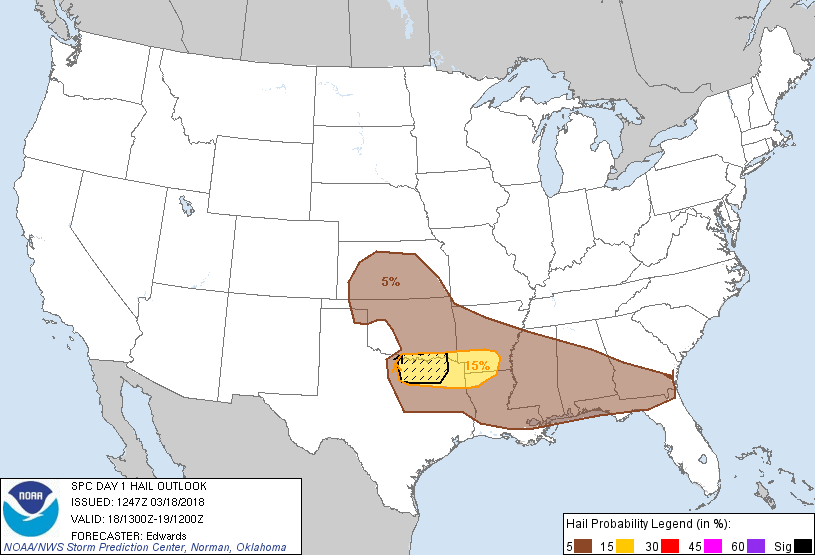 It must be noted that the severe threat is still somewhat uncertain, as the advancement of moisture could prelude any severe thunderstorm development. But at the same time, the general idea is that moderate instability in a sheared environment with a marginally sufficient Low-Level Jet will support the risk for a few severe storms this evening. Threat - Any isolated storm that forms this late afternoon and evening will have the potential to turn quite severe with all modes of severe weather possible, including the potential for a couple of tornadoes. However, the steep mid to low level lapse rates will support the risk for mainly very large hail. Other factors continue to suggest that significant/2" stones are likely, with the potential for 3" or greater stones with the more discrete supercells. Any tornado potential will be confined to the DFW metro any places along the Red River area. Rain - Rain amounts today will stay very light; under 0.15 inches in most spots. Flooding will not be a concern today. Timing - An initial batch of showers and rain will move in from the west at around noon. Severe thunderstorm development is expected somewhere between 2-3 pm. The main peak hours for the most intense cells are around 5-7 pm. We will remain dry for the rest of the night. Closing Thoughts - As previously mentioned at the top of this both, severe weather threats are very common since mid March falls in the regular spring severe weather season in the Plains. This is good practice for everyone to be prepared (not scared) should we have a dangerous severe weather day sometime this year. Make sure that you have multiple ways of receiving severe weather warnings. NEVER RELY ON AN OUTDOOR SIREN!!! You will have NO chance of hearing them if you are indoors, especially if you are asleep. We recommend that every home and business has a NOAA Weather Radio. If you are looking for a good weather app for your smartphone, we recommend WeatherRadio by WDT. Be sure to check the 'Severe Weather Prepardness' tab on this website for more information on how you can keep you and your family safe. 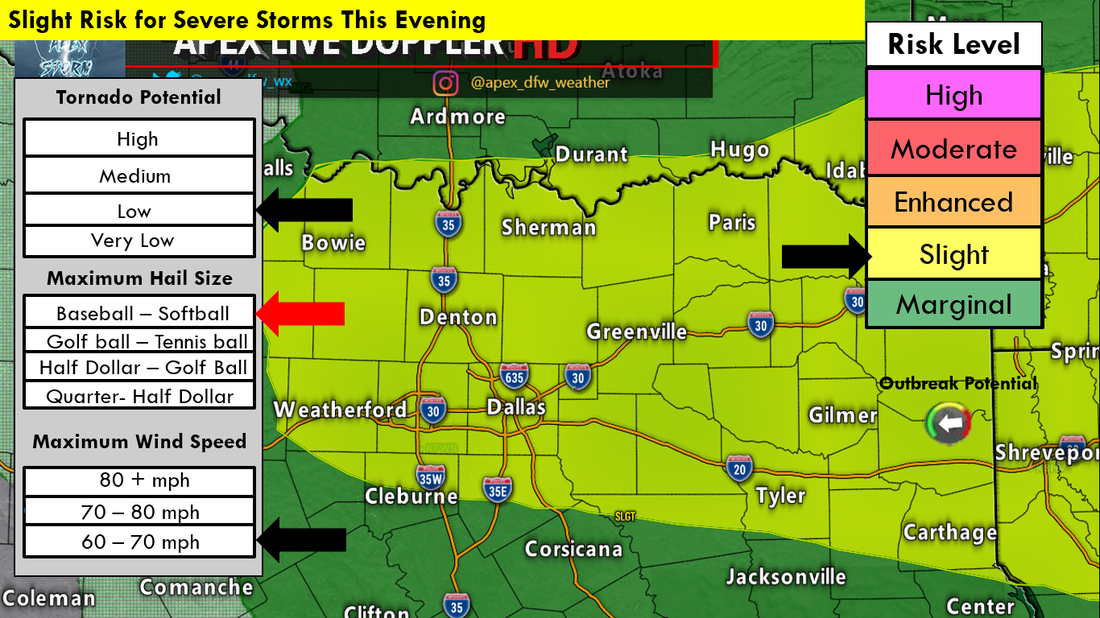 The Storm Prediction Center has areas along and south of I-20 in North Texas under the standard Slight (category 2) risk for severe weather this afternoon and evening. For now, it looks like we will be dealing with all modes of severe weather, including the potential for a couple of tornadoes. 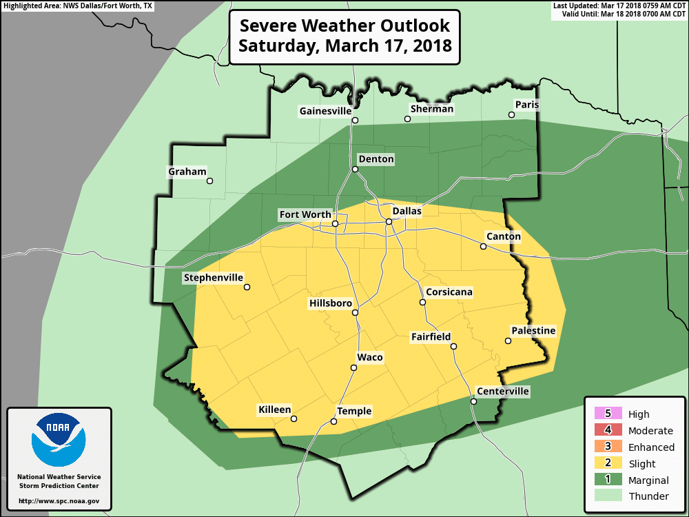 CURRENT CONDITIONS - It may feel dry now, but dewpoints are currently in the mid 60s as far north on a line from Hillsboro to around Tyler. As more moisture from the gulf surges northward, we will see these dewpoints increase throughout the day.  As we progress through the day, a cold front will slowly move in from the north, and stall somewhere along the I-20 corridor. Areas to the south of the stalled front will have the best chance of seeing thunderstorms as the moisture interacts with the cold front. Once we get into the afternoon hours and daytime heating starts to take effect, a surface low is expected to develop in west Texas near Abilene. While that is taking place, a dryline will establish itself to the south of the surface low. Storm initiation is expected to occur along and areas to the east of the dryline, more specifically around Coleman and Lake Brownwood, just to the southeast of Abilene. The best time for storm initiation is around 2 to 3 PM. Areas to the south of the cold front and to the east of the dryline will have the best chances of having severe storms. 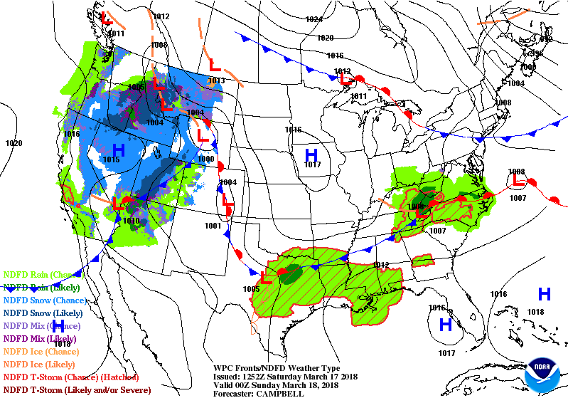 So how unstable will we be by the afternoon hours? - If we were to base this off of the High-Resolution Rapid Refresh Model (HRRR), the Most-Unstable CAPE values will likely exceed 2400 j/kg after 4PM. This is obviously sufficient for severe thunderstorm development, especially this early in the season. Moreover, steep low to mid level lapse rates will support the risk for large, and locally significant hail with the strongest storms. However, low level shear and hodograph sizes may be limited this evening, but shear vectors will still be in excess of over 50 knots. Therefore, some tornado potential may develop with the storms that remain discrete in nature, but will be very isolated. Storms will increase after initiation, and the activity will move to the east towards the Ark-La-Tex region.
Most of the day should be dry, but the bottom line is - I would not cancel your plans this afternoon. The most likely timing for storms to enter the DFW metro is 4 to 6PM. For now, all modes of severe weather is possible, but will remain very isolated. Be sure to check this page for updates throughout the day. Also, be sure to use our interactive radar on our website! 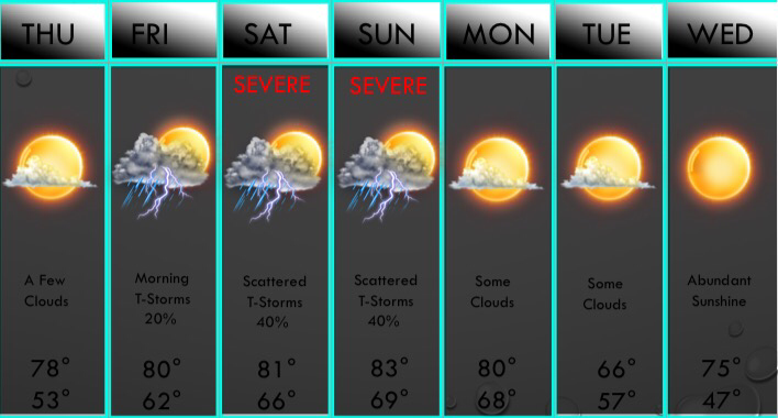 We have a few chances of storms returning this weekend, so let's dig in and talk about what's going to go down! First of all, there's a very slight chance that a few storms may develop northeast of the DFW area Friday morning along a weak cold front. This will have no impact on temperatures on Friday, just a wind shift. We should see mainly sunny skies heading into the afternoon hours with scattered cumulus clouds overhead. No storms are anticipated in the DFW area at this time. A disturbance will draw in some moisture from the Gulf of Mexico late Friday night, and with lift, scattered thunderstorms will develop during the daytime hours on Saturday. The latest European and American model both have a cluster of storms bringing strong winds and hail to the Dallas/Fort Worth area during the evening hours on Saturday. Below is the risk area map for severe weather on Saturday. 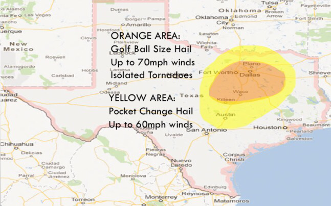 A few storms may be capable of quarter to golf ball size hail, 60-70mph wind gusts, and possibly a weak tornado late Saturday afternoon into the evening hours. The highest risk will be in the orange shaded area, which will favor areas along and south of D/FW towards the Waco area. T-Storms will also produce heavy rain and lightning. Any remaining storms will linger into Sunday morning mainly north of D/FW. By Sunday midday, isolated storms may develop in North Texas. These will pose a high wind and hail risk in the D/FW area. Then we will be watching a surface low and a dryline/cold front combination during the late afternoon and evening hours. As this approaches our western counties by mid afternoon, a cluster of strong to severe thunderstorms will develop. This will congeal into a line by evening with large hail, straight line winds, and a brief tornado threat in the DFW metroplex. Below is the severe map for Sunday afternoon. 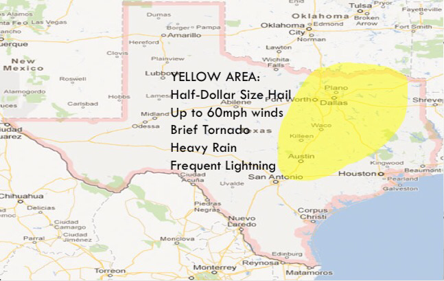 PWATS will be higher during the evening hours on Sunday, so heavy rain will also be a threat during the afternoon/evening. All storms will exit the area late Sunday night and we will clear out on Monday and all of next week looks mainly dry and pleasant, but storm chances look to return next Thursday and Friday. It is way to early to predict any severe weather.
-Jonathan Williams 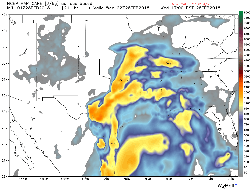 Above is predictive CAPE values tomorrow afternoon. Most data kept it less than 1000 today, but now it's over 2000! This means our severe potential tomorrow evening is higher. More on that in a second, but let's talk overnight and tomorrow morning.
Widespread dense fog has developed over the past few hours, and we may see a shower or storm this evening NE of DFW. Some rain moves in near daybreak tomorrow. Some rain could be heavy at times, but I don't have any severe storms in the morning. A few rumbles of thunder and strikes of lightning are possible however. Rain will continue through midday, and numerous showers and storms are expected through 5PM. We may see a lull from 5PM until 7pm. But, a squall line of strong to severe storms will develop out to the west by 7PM. Since instability will he higher than expected, the slight risk area will likely include Dallas/Fort Worth tomorrow morning, and an enhanced risk is possible east. The main threats with these storms will he some large hail and damaging winds, but a tornado is possible in D/FW. The primary time is from 7pm-11pm with these strong thunderstorms. Flash flooding may be a threat because storms may produce torrential rainfall at times. Cloud to ground lightning is likely along with some very intense and loud thunder claps! The storms will move east of the area late in the night, and Thursday, Friday, and Saturday will be sunny and dry days. A chance of storms return on Sunday, some of which may be strong to severe, and a few showers and storms are possible Monday, some may be severe as well, mainly east of the D/FW metroplex. Some storms will return late next week, and with a very unstable atmosphere indicated by the European, some more severe weather will be possible. Some colder air may return by next weekend, but no extreme cold or winter weather is expected. The NAO will take a dip to negative again in late March, and some wintry weather may return in that timeframe. (Yes, it can still snow in late March) Have a great evening! -Jonathan  SIMULATED RADAR FOR 9:00AM TOMORROWWidespread fog and heavy drizzle has developed across the entire Dallas/Fort Worth area, and a Dense Fog Advisory is in effect until 4:00AM tonight. A warm front is lifting north through the region as we speak, and temperatures are expected to rise for areas south of I/30. (Including the metroplex) As this front lifts north and we are in the warm sector, this is when I expect scattered thunderstorms to develop near daybreak tomorrow. Storms will move in from the south near 6-7AM, and these storms will have the potential to produce large hail and very heavy rainfall. Then as we head into the mid morning, things really begin to become interesting. A cold front/dryline combination will move into the region, with severe thunderstorms developing along these upper level features. An intense line of storms will develop in our western counties by 9AM, and this is when the DFW area will need to be on high alert. We will watch for any discrete supercellular storm development, and if these storms develop, we may have an enhanced tornado risk in the Dallas/Fort Worth metroplex. We will watch this closely. Late morning, this squall line of severe storms will move into DFW. Large hail, damaging winds, and embedded tornadoes are possible. A SEVERE THUNDERSTORM WATCH or a TORNADO WATCH will likely be issued tomorrow morning for the DFW metroplex. By afternoon, all storms will push into East Texas, and the severe threat will continue out there. Mainly cloudy skies will remain during the afternoon, but I think some sunshine is likely! Dry weather returns Sunday and Monday, with storm chances returning Tuesday and into Wednesday, with another potential of heavy rain and severe storms exists, especially on Wednesday. Dry weather is expected late next week. There is still no sign of wintery weather in the next 10 days, but as I've said, March may have a few periods of colder weather, so we will see if we can get some cold air back into North Texas with some snow to come with it! The updated seven day forecast will be uploaded to the website by 9:00pm tonight. Follow me on twitter @wx_dfw as I will be providing you will information and any warnings or watches issued in the Dallas/Fort Worth area tomorrow morning. -Jonathan  ABOVE IS A RADAR SIMULATION FOR 4:00 AM CST.
Strong to severe thunderstorms will move in late tonight into daybreak tomorrow. These storms may contain quarter size hail and damaging winds, and an isolated tornado cannot be ruled out west of I/35. Instability looks quite impressive, especially considering that this is an overnight event, when we usually stabilize. Instability will be near 2,000 jKg overnight, which is very supportive for severe weather. The leading edge of this complex is the concern. Notice the purples along the leading edge? That's very heavy rain and hail. And notice how it's bowing out? That's a sign of a damaging wind threat. Here's one of my concerns: Discrete storms may develop just ahead of the main line. These will be capable of large hail, and possibly a low tornado risk. The storms may also dump 1-2" of rain across the DFW area. Some areas may see 3-4" which may aggravate flash flooding, mainly in those low-lying areas. But, this will not be a major severe weather outbreak, but several severe thunderstorms are possible along the leading edge. I am always available on social media on twitter @wx_dfw so feel free to message me and I will answer your questions. Also message @apex_dfw_wx and he will answer your questions as well. We are both here and will post as this line of storms approaches and will let you know of all watches and warnings that are issued by the National Weather Service™ in Fort Worth, Texas. -Jonathan  Winter Who? - It feels more a muggy spring day across North Texas this late morning. We are in mild conditions this morning with temperatures in the 70s at 10:08 with no sun at all. Actually, now that you think about it, no sun is actually a good thing in these scenarios, because it is dry now, but strong to severe storms will be possible this evening and overnight, where the Storm Prediction Center has introduce a "marginal" risk for severe storms for much of West Texas and some parts of the North Texas coverage area, including some parts of the DFW metro. 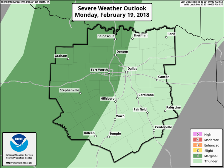 Strong to possibly severe storms will be more likely in the areas shaded in the darker green. Though it will not be a widespread event, some of the strongest storms could produce large hail at times, and maybe some gusty winds. A brief spinup cannot be ruled out. Sounding Analysis - This is analyzed from a weather balloon that is launched multiple times each day. Pay attention to the upper left part of the sounding, most notably the red and dotted brown lines. The solid red line represents the temperature and the dotted brown line represents the air parcels, AKA, instability. The red line intersects the dotted one at 850, which means that there is currently a cap in place. A cap serves as a layer of warm air that suppresses the development of severe thunderstorms. If we can get the capping inversion to erode this late afternoon, a few supercells will be possible within the marginal risk area. 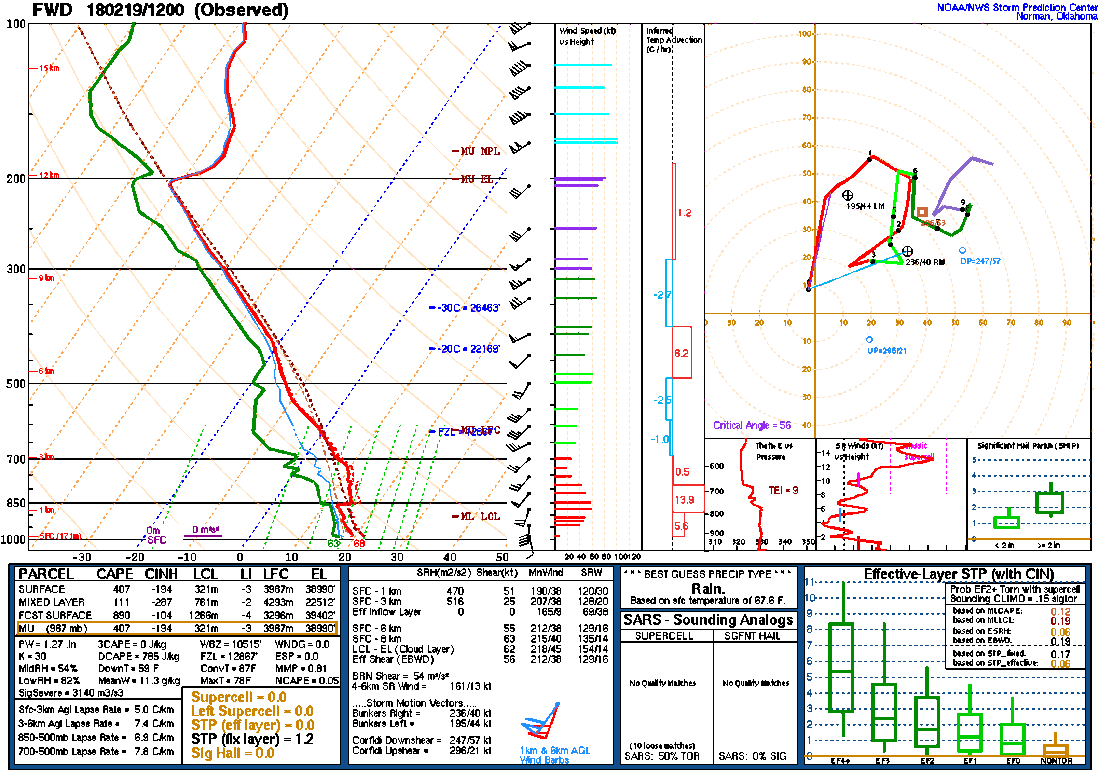 IF the cap can erode this evening, there will be sufficient buoyancy and vertical shear (shown in the sound) for storms to produce some large hail, a few bowing segments, and one or two tornadoes. As details become more clear, an upgrade may be warranted in later outlooks, so stay tuned. Timing - Keep in mind that this will mostly be an overnight event, be aware as this may make for a wet commute during the pre-dawn hours on Tuesday. We will continue to see rain at times for the rest of the day today, but not all day. There will be a small window this evening where any isolated thunderstorm that develops has the potential to turn marginally severe with large hail and damaging winds. Then, overnight, a complex of showers and thunderstorms overspreads north Texas overnight, but some embedded supercells will be possible within the complex. Those storms will have more of a damaging wind and hail threat. Anything leftover during the pre-dawn hours will likely be just rain and some thunder, so pack an umbrella and be prepared to drive slowly tomorrow morning. We will provide updates throughout the day, so be sure to check back frequently. 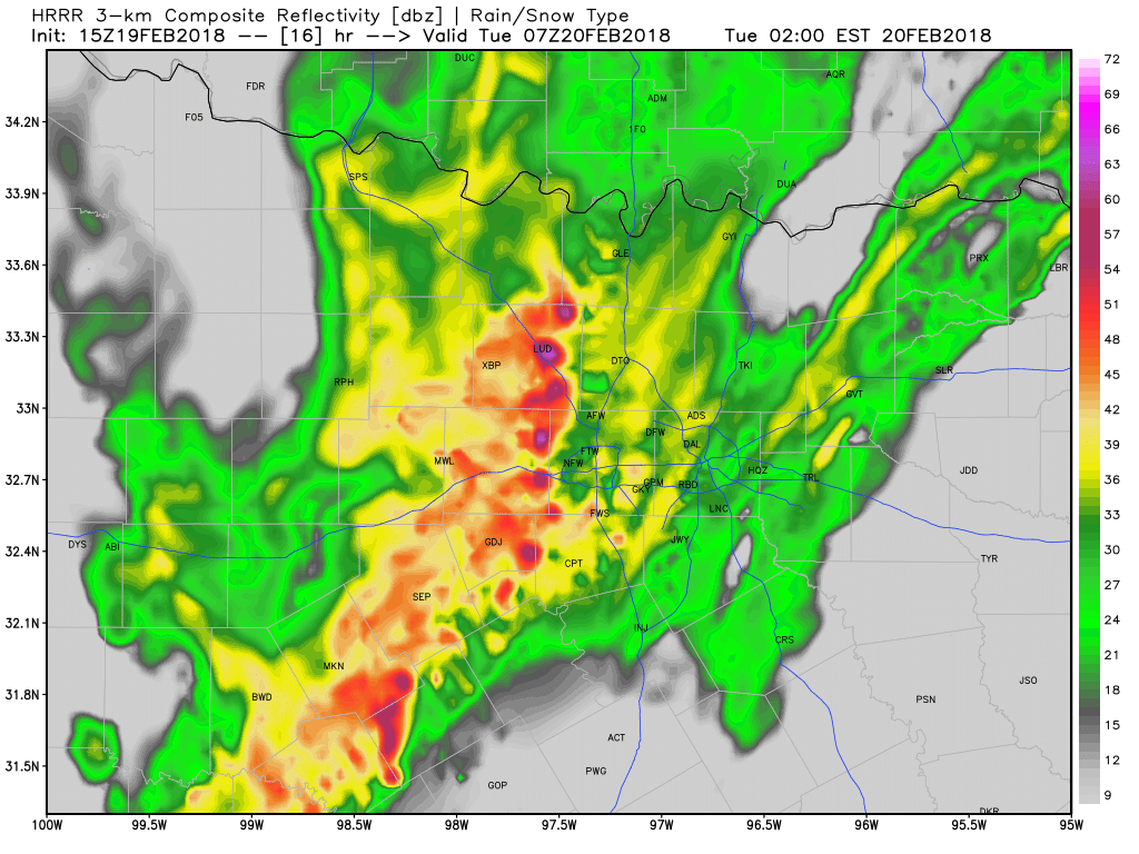 |
AuthorWrite something about yourself. No need to be fancy, just an overview. Archives
March 2021
Categories |
 RSS Feed
