
|
This blog was written and released at 7:30 AM CDT on March 25, 2021. Just like with any weather extreme, it is imperative that you are working with fresh information. If you are working with information that is 10-12 hours old, you are working with bad information. If you are in the the Deep South, be very weather aware today! A tornado outbreak is expected this afternoon and evening across parts of the Deep South today into the Tennessee Valley. Several intense, long-track tornadoes, very large hail, and destructive winds are all possible. Everyone needs to pay special attention to any watch and warning that is issued today. SPC CATEGORIES - A strong upper level trough will generate a stronger upper low over the Miss-Ark-Ten corner, which will interact with a buoyant, volatile airmass to bring a major severe weather threat. The Storm Prediction Center (SPC) has issued a very rare High Risk (level 5/5) of severe weather for parts of central, eastern, and northern Mississippi into Northwestern Alabama and Southern Tennessee. A Moderate Risk (level 4/5) exists for the central 2/3rds of Mississippi, Alabama, into most of central and western Tennessee, expanding into extreme southern Kentucky. An Enhanced Risk (3/5) surrounds those two risks from about 25-50-75 miles. 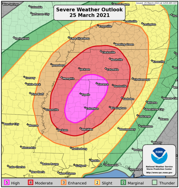 Before I proceed further. I encourage everyone to not get hung up on the exact placement or name of these risks. Storms do not follow these colorful guidelines and have no idea where they are. Many tornadoes that occurred with last Wednesday's tornado outbreak did not occur in the high risk zone. Some red letter severe weather days happened on moderate risk days. The point is that everyone that is in the Enhanced Risk (3/5) and higher need to pay special attention to the weather over the next 24 hours, and finalize tornado preparations this morning. SYNOPSIS - Just like last Wednesday, a negatively tilting trough with a high wind gradient will spin up an upper low over the triple point located on the Mississippi River Valley. Warm, moist, unstable air will already be covering most of the Deep South. The mid-level jet will become coupled with the low-level jet by the afternoon and evening hours tomorrow, creating a favorable combination of lift, shear, and helicity for potentially intense tornadoes and very large hail, and damaging winds. The greatest probabilities for a regional outbreak of tornadoes is forecast in the moderate risk and high risk areas. In addition to the tornado risk, very large to giant sized (golf ball sized or larger) hail and wind damage will like be likely across a large part of Mississippi and Tennessee into parts of Alabama, Arkansas, and extreme northeast Lousisana. The threat for damaging winds is expected to increase as a mesoscale convective system (MCS). The wind damage threat is forecast to become more widespread as a squall line organizes along a cold front in the Mississippi Valley. This line of severe storms is forecast to move quickly eastward across the Ohio and Tennessee Valleys this evening, producing widespread wind damage. TIMING - Non-severe thunderstorms are ongoing across the northern part of the region this morning. Some of the storms could be strong to marginally severe. The severe weather threat associated with morning batches are very low. However, on days like today, we will have to continue to closely monitor. Afternoon storms will begin to develop to the west by noon, where they will be scattered in nature. Any storm that develops in the afternoon could quickly turn severe. The peak of discrete supercell thunderstorms for Mississippi, Alabama into parts of Tennessee will come from around 1PM - 11PM tonight. THREATS - ALL modes of severe weather will be possible this afternoon and evening, including the threat for VERY large hail, widespread wind damage and several tornadoes. A few intense, long-track tornadoes are forecast, including the potential for a violent tornado or two in the mix. UNCERTAINTY - With any severe weather event, comes with the air of uncertainty that could either make for a worse-case scenario or for storms to not be as intense, which is ultimately what we want. Elevated convection within the warm sector is expected during the morning hours, which could dampen the overall severe potential, or produce enough outflow to introduce a higher-end tornado potential. In addition, the extent of the convective inhabitation has not been realized yet. The abundance of rain, storms, and other non-severe storms precluded violent long track tornadoes from occurring last week. This week, we are in the same situation again, which may limit the overall tornado potential. Regardless of the extent of moisture abundance in the most affected zones, several intense tornadoes are expected across the Deep South today, and a High Risk was issued this morning to address that threat. WiLl tHiS bE LiKE aPRiL 27tH, 2011?: I really do not like this question at all. 216 tornadoes were confirmed that day, with a third of them being strong to violent. Those are generational events. Meaning, they tend to happen once every 40 years or more. However, bear in mind that if there is only one tornado in your state, and that happens to come down your street, that is YOUR April 27th, 2011. PREPARE, PREPARE, PREPARE: You know the drill. People across the Deep South did a REMARKABLE job in preparing for a red letter severe weather outbreak, as over 40 tornadoes were confirmed, and not a single casualty resulted from that, despite major damage in many places. We need you to have the same level of preparedness today. Just like March 17, this is not a day to play around with. Treat every tornado warning as if there is a tornado on the ground, doing significant damage. That is more than likely what we are going to be seeing across the Deep South today. Today is day where you and your family need to keep ready for severe thunderstorms. Be sure you have multiple ways of receiving warnings. NEVER RELY ON A TORNADO SIREN. First, make sure you have a NOAA Weather Radio. Every home in the Deep South needs one as they work off of their own network, making them very reliable. On your phone, make sure you have WEA (Wireless Emergency Alerts) enabled on your phone. To make sure of this go to Settings > Notifications > scroll all the way down to the bottom to ensure that "Emergency Alerts" are enabled. Find the safest place in your home. It is typically in a small room, on the lowest floor, near the center of your house, away from windows. In that safe place, have helmets for everyone, airhorns (in case you are injured and need to alert first responders on site), and hard-sole shoes (if you must walk over tornado debris). If you live in a mobile home, you can not stay put during a tornado warning. Identify the nearest location of a shelter or safe place, and know how to get there at a moments notice. More severe weather prep tools can be found here. MAP LITERACY - Just about anytime we forecast extreme weather, we get dozens of messages that consist of "what about *insert town or city here*". Most of these messages come on posts with references to counties or major highways. In my five years of doing this, I have learned that several people struggle with geography, and more specifically have a tough time trying to read maps. I understand. I struggle with many things to. If you were to give me analytic geometry questions, I would look at you like you just shot a man before my eyes. But there is no way we can name hundreds of municipalities on every post. I encourage you to take a few minutes to learn the major highways and counties relative to your location. I promise it will help you understand the blog entries and the posts I make here addressing any time of weather extreme.
YOU ARE GOING TO BE FINE - I am well aware that we are in a time in our society that most people in the South, and nationwide, are suffering from high anxiety from a global pandemic and civil tensions. The last thing we want as trusted forecasters is to add to that anxiety. However, at the same time, we must present the weather situation the way it currently stands. I understand we have many people across the south who have a literal phobia of thunderstorms and tornadoes. If you are located anywhere in the Deep South, just know that there is no reason to panic about today. Even during a severe weather outbreak, the chances of a tornado hitting your house are low, as tornadoes are tiny compared to counties, or the entire state. Unfortunately, lots of amateur weather weenies are on the social media outlets today using a myriad of scare tactics, which is ridiculous and irresponsible. They do not have any prior knowledge behind the different models and maps, what they mean, or how to interpret it. Yet, people will share them without second guessing. Please stay away from these pages, as nobody needs more anxiety. Only get weather information from trusted sources (like this blog and our social media outlets).
Donovan Neal Owner - ApexStorm Good morning, I usually write entire blogs for a weeks worth of a forecast, but this time we are only talking about 2 potential severe weather days in North TX, with those being Saturday and Sunday.
TO START OFF: Saturday morning will be mainly dry for DFWx but thunderstorms will be erupting across West Texas/Western North Texas. These will track eastward towards the DFW area, most likely arriving early Saturday afternoon. These storms will be capable of large hail and strong wind gusts. However, the tornado risk is up in the air due to uncertainties about if the storms become surface based. Most likely, the storms will be elevated. We will watch and see any potential of surface based convection. The storms will continue through the evening and will maintain that severe threat. A dry period will begin in the evening, but rapid destabilization despite it being dark outside due to steeper mid-level lapse rates associated with the ejecting trough. This will set the stage for a potentially greater risk of severe storms during the overnight hours. Storms will develop to our W/SW and push into North Texas early Sunday. Despite unfavorable timing, favorable instability and strong shear will keep a severe threat in play. Low level shear will be stronger as well as a kicking LLJ, therefore the tornado risk will be greatest during this time, as well and damaging winds and hail. Additional thunderstorms may develop late Sunday afternoon along a cold front as well, and a few of these may turn strong with hail and gusty winds, but the severe risk appears low at this time. Logan Shipley After a cloudy and fairly chilly day in the 50s (relative for March) widespread rain will move in late tonight. Some of this could be heavy at times, with 1-2" possible in some spots. Best chance is north of I/20, where we have advertised a 100% chance of rain. No severe storms are expected with chilly temperature, but a few storms with lightning and a little small hail aren't completely out of the question.
These will move out by mid morning tomorrow, but a couple scattered showers will linger through the day. Highs will be in the 60s. Tuesday and Wednesday will have scattered afternoon storms, however both Tuesday night and Wednesday night a line of potentially strong or severe thunderstorms may develop in West Texas and make a run at North Texas. Right now, I think they stay northwest especially Tuesday night. Wednesday nights forecast will have a large affect on Thursday. If a line of storms comes in Thursday morning, we will have to see how much destabilization we can have during the afternoon. If there is enough, strong or severe thunderstorms will likely redevelop. There's also a possibility that the squall line stays north and west of the area, and that would increase the risk of severe storms Thursday afternoon and evening along the dryline. IF storms develop, they would be capable of large hail, damaging winds, and isolated tornadoes. Stay tuned on that aspect of the forecast as we work through details. A strong cold front will push in Thursday night, and an additional line of storms may develop. Some of these will pose a severe threat as well. Friday will be cooler in the 60s, and a few morning showers or storms will be possible. Saturday and Sunday will be chilly in the 40s and 50s potentially, with increasing rain chances as a disturbance approaches from the south. Nothing heavy or severe is projected at this time. Logan Shipley Before you read any further, please be advised that this is not unprecedented, or out of the norm for North Texas. Around this time of the year is where we start to see our late severe weather season take place, and today will be no exception to that. Let's start off by saying the majority of your Sunday in North Texas will be dry and sunny with the DFW High at 87°. Things will start to get more interesting this evening, first starting to the north around Texoma and our Red River counties, expanding southeastward into the North Texas area. SEVERE WEATHER RISK TONIGHT: There is an "enhanced risk" (level 3 of 5) of severe storms for areas to the north of Interstate 30 and along and east of Interstate 35. This is the area outside of the Greater DFW Metroplex. Surrounding that risk, we have the standard "slight risk" (level 2 of 5) of severe storms for the rest of our North Texas, excluding those past the I35 split just to the north of Waco. Lastly, a marginal risk (level 1 of 5) encompasses much of the Central Texas area.  Keep in mind that storms do not know where these specific zones are and do not follow them as such. These are just guides to illustrate where the best combination of thermodynamics and dynamics resides tonight.
TIMING: An isolated severe thunderstorm or two could develop at around 5PM around the Texoma area. However, a strong cap, or warm layer aloft, will inhibit thunderstorm development until around 7 to 9PM. Most of the thunderstorm development will take place at around 9PM to 12AM across North Texas with a south/southeastward moving cold front. The overall coverage of thunderstorms will maximize at around 10 to 11 PM as storm congeal into an organized squall line. THREATS: Storms will begin in more of a discrete mode, which will favor the possibility of very large hail (up to the size of baseballs) and a couple of tornadoes, followed by a threat for damaging winds. The severe potential will be maximized for the areas just to the northeast of downtown Dallas, where the highest risk is. If any supercellular storm becomes long-lived, it may have the potential of putting down a strong tornado, but the chance of that occurring is really low at this present time. As storms congeal to a solid line over time, the threat for damaging winds and hail will be maximized. By midnight, the main storm mode should be damaging wind gusts and brief, isolated tornadoes. CALL TO ACTION: Make sure you can hear severe weather watches and warnings this afternoon. Know where you are going if you happen to find yourself under a tornado warning. Lastly, take a moment and review your readiness kit in your safe place, including helmets, air horns, and hard sole shoes. For more information, including thoughts and apps for your phone, please see this post. After storms move through during the middle of the night, expect a very cool morning with temperatures starting in the mid 50s, warming to the low 70s by the end of the day tomorrow. Keep tabs on the blog and our twitter feeds later today for frequent updates as they happen! RADAR CHECK - A cluster of showers and thunderstorms is currently in progress over Ellis and Kaufman counties. Showers continue to spread northeast for our western counties, just to the east of Abilene.  This period of "lull" will persist throughout the day. We will remain mostly cloudy with afternoon highs reaching towards the upper 70s. Similar to Monday, but just a few degrees cooler. A FEW SEVERE STORMS POSSIBLE OVERNIGHT - If you don't already know, we have been monitoring the potential for a few severe thunderstorms across North Texas ahead of another strong cold front that will bring another rush of cold air into the region (I'll get to that later). The latest Storm Prediction Center Severe Weather Outlook places much of North Texas under some risk of severe weather. To elaborate, the SPC has defined an area of standard "slight" risk (level 2/5) of severe storms for starting to the west of Fort Worth to the lower Ohio Valley. A marginal risk (level 1/5) of severe storms extends from the east of San Angelo to the lower Ohio Valley. It should be noted that these convective outlooks are valid until 6:00 AM the following day.  Please keep in mind that these outlooks are just a general guideline, and thunderstorms can care less about these lines and colors, so don't get too caught up with it. Everyone that is involved in a risk has a fair game of seeing some type of strong to severe thunderstorms this afternoon and evening.
TIMING - A cluster of thunderstorms is already impacting Southern Oklahoma along a stationary warm front (which will eventually turn into a cold front by the time it moves through North Texas). Some development is possible for the counties closest to the Red River, but the main severe weather window for North Texas will mostly come during the overnight hours into Friday morning. Earlier mesoscale model runs showed a couple of supercells reaching the metroplex right around dinner time (which would have a higher likelihood of turning severe), so don't be alarmed if there are a couple of storms by the evening, but remember, our main window for weather would be overnight. THREATS - There is just a bit of uncertainty regarding whether or not the severe storms will be surface-based or just ever so slightly elevated above the cap. Storms would yield more of a low-end tornado risk if they happen to become slightly elevated about the cap. All modes of severe weather would be more likely if storms become more surface-based. In either scenario, a hail threat exists. RAIN - There is a chance that the storms that come through overnight may get undercut by the cold front, mitigating any risk of severe weather. One way or another, there is a good chance that we will get wet while you are asleep. But rain amounts should stay under 1/2 inch for many communities. If you put this into perspective, overall severe weather risk for North Texas is not high, meaning, we are NOT expecting a widespread severe weather event/outbreak. This is just a routine threat of strong to severe thunderstorms that you will see more commonly as we head into Meteorological Spring. Keep in mind that any storms left over by midnight will more than likely get undercut by the cold front, cutting off the supply of unstable air. However, it is not wise to get complacent about these severe weather risks. We can use this as good practice for when we actually have a severe weather event. It is a good idea (when you get home) to clean out the storm closest or basement and have a reliable, robust way of receiving warnings (NEVER RELY ON STORM SIRENS AS YOUR PRIMARY METHOD OF GETTING WARNINGS!!!). Just make sure you are working with fresh forecasts. If you are viewing a forecast that is at least six hours old, you are working with bad information. Be sure to follow me and Jonathan William's twitter handle for the latest updates regarding today! We will go live whenever warnings are issued for the North-Central Texas region. Donovan Neal CEO of ApexStorm - Weather and Band Forecast Company NOAA Weather-Ready Nation Ambassador SKYWARN Spotter Certified On June 23, 2018 the NWS has issued a “Moderate Risk for parts of Southern Kansas & Northern Oklahoma for June 24, 2018. So, you might be asking what’s a Moderate Risk? Or how bad is a Moderate Risk? A moderate risk is the 2nd highest rating for Outlooks (1st being High Risk). So how bad is a Moderate Risk? Well, it’s pretty bad. For moderate risk, there’s a likely chance for severe weather. Large Hail, Widespread Wind Damage, Long Track & Strong Tornadoes are expected for moderate risk days. So far, we haven’t had a lot of tornadoes being EF-3+, so far of this post there has been only 5. But tomorrow, could increase that amount. If your in the Slight Risk Areas - Moderate Risk, make sure to tune in to your local weather stations tomorrow! To stay up to date with Tornadoes & Severe Weather Follow My Twitter @TornadoHub. CRedit for the Pictures: NWS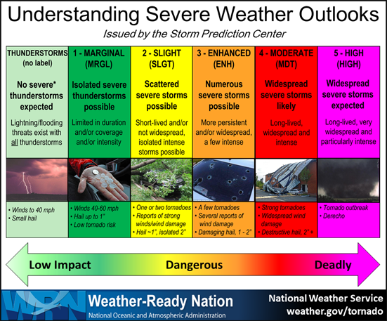   On June 14, 2018 a Tornado touched down in the town of Wilkes-Barre, PA around 10:00 PM EST. The NWS has confirmed a EF2 Tornado with estimated wind speeds around 130 MPH. Reports say that the tornado touched down near the La-Z-Boy furniture store at Mundy Street at Highland Park Boulevard and ending near Interstate 81 behind Dick’s Sporting Goods in the Arena Hub Plaza. A lot of buildings have been destroyed including: - Panera Bread - U-Haul - Tovon Jewelers - Kurlancheek Furniture - Sneaker King - LA Nails and many more. Credit goes to these websites for the pictures: Philly Voice & Trending Hits Follow my Twitter Account @TornadoHub for instant updates on Severe Weather!    #BREAKING - The NWS/SPC has issued a severe thunderstorm watch (large hail 2”+, 70mph winds, a tornado or two) until 2P. #txwx #dfwwx #ntxwx #apexwx #texasweather #texas #dallas
After a day of showers and storms, some severe, I think it's a great time to talk about what May will hold. Unfortunately, we look to have a very stormy may with plenty of severe weather.
Looking at long range data, NAO will turn into a negative phase. The storm track looks to be placed RIGHT OVER Texas. This will bring lots of thunderstorms, and in the early part of May, we may have a chance of strong storms each day. This is a fairly usual pattern, but this May looks to be even stormier than normal. We also look to have an active dryline through the month. This typically sets up squall lines of severe thunderstorms capable of producing large hail, damaging winds, tornadoes, and flash flooding. We will closely watch that. We will also may have an active frontal pattern in the area. This will allow for plenty of lift through the month with deep instability. And with the storm track over us, we may have quite the stormy month. 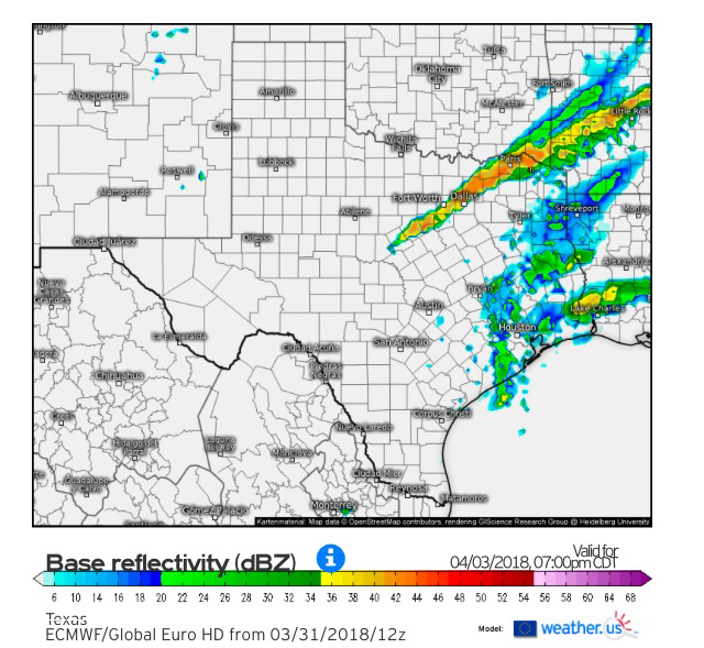 simulated Radar 7:00Pm tueSDay (4/03) A cold front will kick off showers and thunderstorms Tuesday evening across North and Central Texas. 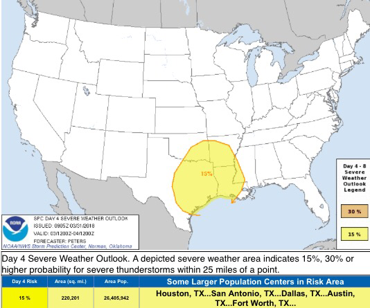 day 4 severe weather oUtlook via spc |
AuthorWrite something about yourself. No need to be fancy, just an overview. Archives
March 2021
Categories |
 RSS Feed
