
|
Before you read any further, please be advised that this is not unprecedented, or out of the norm for North Texas. Around this time of the year is where we start to see our late severe weather season take place, and today will be no exception to that. Let's start off by saying the majority of your Sunday in North Texas will be dry and sunny with the DFW High at 87°. Things will start to get more interesting this evening, first starting to the north around Texoma and our Red River counties, expanding southeastward into the North Texas area. SEVERE WEATHER RISK TONIGHT: There is an "enhanced risk" (level 3 of 5) of severe storms for areas to the north of Interstate 30 and along and east of Interstate 35. This is the area outside of the Greater DFW Metroplex. Surrounding that risk, we have the standard "slight risk" (level 2 of 5) of severe storms for the rest of our North Texas, excluding those past the I35 split just to the north of Waco. Lastly, a marginal risk (level 1 of 5) encompasses much of the Central Texas area. 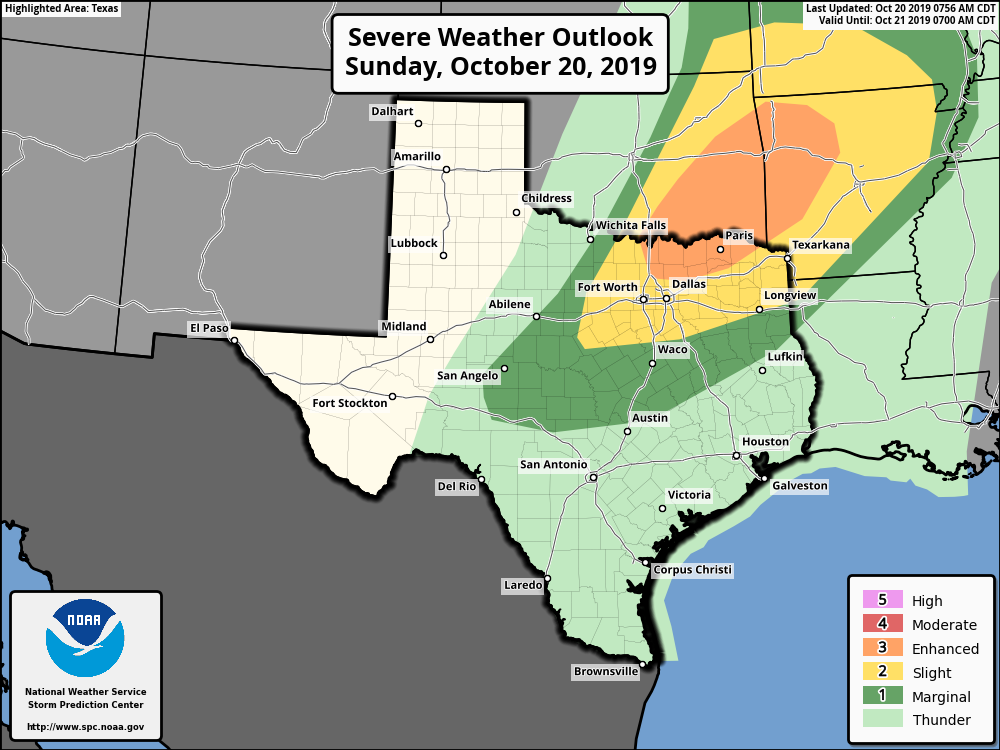 Keep in mind that storms do not know where these specific zones are and do not follow them as such. These are just guides to illustrate where the best combination of thermodynamics and dynamics resides tonight.
TIMING: An isolated severe thunderstorm or two could develop at around 5PM around the Texoma area. However, a strong cap, or warm layer aloft, will inhibit thunderstorm development until around 7 to 9PM. Most of the thunderstorm development will take place at around 9PM to 12AM across North Texas with a south/southeastward moving cold front. The overall coverage of thunderstorms will maximize at around 10 to 11 PM as storm congeal into an organized squall line. THREATS: Storms will begin in more of a discrete mode, which will favor the possibility of very large hail (up to the size of baseballs) and a couple of tornadoes, followed by a threat for damaging winds. The severe potential will be maximized for the areas just to the northeast of downtown Dallas, where the highest risk is. If any supercellular storm becomes long-lived, it may have the potential of putting down a strong tornado, but the chance of that occurring is really low at this present time. As storms congeal to a solid line over time, the threat for damaging winds and hail will be maximized. By midnight, the main storm mode should be damaging wind gusts and brief, isolated tornadoes. CALL TO ACTION: Make sure you can hear severe weather watches and warnings this afternoon. Know where you are going if you happen to find yourself under a tornado warning. Lastly, take a moment and review your readiness kit in your safe place, including helmets, air horns, and hard sole shoes. For more information, including thoughts and apps for your phone, please see this post. After storms move through during the middle of the night, expect a very cool morning with temperatures starting in the mid 50s, warming to the low 70s by the end of the day tomorrow. Keep tabs on the blog and our twitter feeds later today for frequent updates as they happen! |
AuthorWrite something about yourself. No need to be fancy, just an overview. Archives
March 2021
Categories |
 RSS Feed
