ApexStorm
  • Home
  • Headlines
  • Texas Weather
  • Severe Weather
    • Severe Weather
    • Severe Weather Categories
    • Severe Weather Preparedness
  • Radar
  • Drought
  • Advertise
  • Tropical Weather
  • Rain/Thunderstorms
  • Winter Weather
  • Music
    • Music
    • BIo
    • Gallery

Severe Weather 

A few severe storms Possible on Tuesday

3/31/2018

Comments

 
Picture

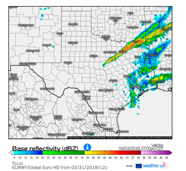
simulated Radar 7:00Pm tueSDay (4/03)

A cold front will kick off showers and thunderstorms Tuesday evening across North and Central Texas.
Picture

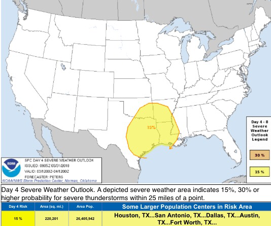
day 4 severe weather oUtlook via spc
​

As a cold front, instability, moisture, lift, warm air, and high severe weather parameters move into the area, strong to severe thunderstorms are forecasted to develop.

The European model has virtually all of North Texas having a severe risk, GFS has areas east of I/35 and south of I/20 having a severe risk, and the Canadian model has all of North Texas having a severe risk, and the NAM only has far southern central Texas and south Texas having a severe risk. So indeed, plenty of uncertainties remain at this time.

While we have uncertainties, we have the general idea that a severe risk will unfold across parts of North and Central Texas, it's just we are uncertain as to which areas will be favored, which is why the Storm Prediction Center has a very broad area circled in the 15% severe probability category, therefore refraining them from introducing any 30% severe probability areas due to very high levels of uncertainties.

Regardless of where this severe risk sets up, any area in North/Central Texas will be quite unstable. The primary risks of severe weather is very large hail and damaging wind gusts, but a few tornadoes are possible with very strong shear in place.

What does all of this mean?

It means that the area should be on alert and staying up to date on the latest forecasts, as we expect models to come to one solution in the next 24-36 hours. Or at least we hope they do! ;)

Which model solution am I leaning towards?

I am completely against the NAM solution, because it is an outlier and it has the cold air on Monday, which would knock out any instability or warm air on Tuesday.
I am leaning towards the global model solutions, because they all seem fairly plausible given the progressive upper level flow. The European model I am most certain with because 1) it's the most accurate model and 2) because the progressive pattern outlook seems most likely, as the GFS model is a bit to aggressive on the overall pattern phase. I will continue to refine my forecast over the next several days. Follow us on twitter @apexwxdfw and @apex_wx_dfw for the latest forecasts and expect blogs throughout the next several days.

Jonathan Williams

Weather Forecaster
Storm Specialist
NOAA Ambassador

Comments

    Author

    Write something about yourself. No need to be fancy, just an overview.

    Archives

    March 2021
    April 2020
    March 2020
    October 2019
    February 2019
    June 2018
    May 2018
    April 2018
    March 2018
    February 2018

    Categories

    All

    RSS Feed

Any Questions, Comments, Concerns or Jokes?


Hours

24/7!

Telephone

N/A

Email

apexwxweather@gmail.com
  • Home
  • Headlines
  • Texas Weather
  • Severe Weather
    • Severe Weather
    • Severe Weather Categories
    • Severe Weather Preparedness
  • Radar
  • Drought
  • Advertise
  • Tropical Weather
  • Rain/Thunderstorms
  • Winter Weather
  • Music
    • Music
    • BIo
    • Gallery