
|
Good evening DFW! Looking at newest guidance, I am considering removing any chance of an isolated storm tomorrow, and I will make that decision tomorrow morning. I will likely raise POPS (Percentage of Precipitation) on Tuesday and Wednesday, and a few of those may be severe. Meanwhile, fog will develop overnight, and that will cause of difficuly travel tomorrow morning. Updates to the forecast will occur tomorrow MORNING. Seven day up and running now, and will be updated by 8:30AM CST tomorrow!
-Jonathan Looking at newest guidance, the area of heavy thunderstorms may not reach the Dallas/Fort Worth area until daybreak tomorrow. This helps migitate our severe weather risk, so I'll remove the risk of severe storms from the forecast overnight, but will keep strong storms in the forecast, some of which may produce pocket change hail and 50mph wind gusts. I do think most storms will remain BELOW severe limits, but one or two *may* attempt to reach severe limits. I think it's very unlikely for any watch to be issued for the DFW metroplex. Widespread thunderstorm activity is expected to continue through tomorrow morning, with rapid development likely close to midday. Some of these storms may produce hail and gusty winds, but sizes of hail and gusts of wind should remain below severe limits. As the cold front approaches tomorrow evening, a squall line of strong storms will develop. Some of these may produce a small damaging wind threat, with the potential of 60mph winds possible in some storms. That DOES reach severe limits, so a marginal risk of severe storms may be issued for tomorrow. Again, a watch seems unlikely with this but will keep an eye on forecast trends.
Concerning Wednesday: The newest guidance has the afternoon freezing line reaching the I/35 corridor during the afternoon hours. Therefore, have lowered high temperatures to the upper 30s Wednesday afternoon. Leaving dominant precipitation type all rain for now, but if the guidance continues this easterly trend of the freezing line, I will introduce freezing rain to the forecast package. All updates to this 7 day forecast will occur tomorrow morning, with the newest seven day being uploaded to the website by 6:30AM in the morning. As always you can follow me on twitter @wx_dfw and follow @apex_wx_dfw for frequent updates on this storm potential and this threat for any ice on Wednesday. Here is your Seven day forecast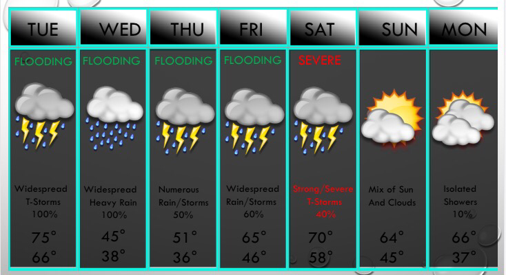 A few isolated showers and storms have developed today, but the cap has held things to a minimum. The cap is now weak, and instability is increasing. Some isolated supercells will develop between 7-10PM, especially west of DFW. This may be a first round of severe storms that affects DFW near 10PM-11PM, but some models have these supercells missing the DFW area and move north of the area into Oklahoma. We will watch this closely and will keep you updated through the evening. Either way, we will be watching an area down to the southwest of the DFW, that will move northeast and produce a large hail and damaging wind threat. Heavy rain and frequent lightning will also occompany the storms. An isolated tornado is possible WEST of DFW. Very small to no tornado threat in DFW but I cannot rule one or two out. This area of storms will enter DFW near midnight-2AM, and heavy rain and lightning will still be going on during the morning commute. This area of rain will move east of DFW during the mid morning hours. We may have some dry time from 10AM-1PM, then widespread storms develop near midday. No severe storms with this round but strong storms are possible. Then by late evening, a strong cold front will move into the region, which will cause a line of storms to develop along the Red River and will push south into DFW. A small damaging wind threat may exist during the evening hours. Temps will quickly fall from the upper 60s near 7PM, to the mid 40s by 9PM. Temps Wednesday morning will be in the upper 30s across DFW. Widespread rain will develop with perhaps some freezing rain or sleet well west/northwest of the DFW area. No winter weather is expected in DFW. Highs will be in the lower to mid 40s across DFW, with 30s northwest of DFW. Temperatures will fall to near 37° Thursday morning with mainly dry conditions, but then widespread rain and storms will develop by midday. No severe weather is anticipated. We will reach 50° Thursday afternoon. The rain will continue Thursday night into Friday, with temperatures reaching the 60s by Friday. Then all attention turns to Saturday as a cold front will work through the area. Some strong to severe storms may develop, with the main severe risk EAST of the DFW area. Cooler and drier air will filter in Sunday with highs in the 60s, possibly some 60s and 70s next Monday. The next front may bring chillier weather and rain chances by the middle of next week.
There are still no signs of wintery weather in the foreseeable future in DFW. But, March may bring some colder and wet weather, so maybe some winter weather chances, as well as some severe potentials, as we all know tornado season kicks off in March. I'll keep you updated this evening. Have a great night! ;) -Jonathan Williams 7 DAY FORECAST Widespread showers and thunderstorms are in the forecast for the next several days, with 3 opportunities for severe storms. The first opportunity will be late this afternoon, especially between 7-10PM, when I expect a rapid development of thunderstorms along the I/20 corridor, perhaps just north of the major corridor. These storms will move north and with a weak cap and sufficient instability, some of these storms will become surface based and produce hail and high winds. The tornado risk this evening is VERY LOW. The second opportunity of severe storms is overnight into daybreak tomorrow, as a complex of strong thunderstorms will be moving in from the southwest, producing very heavy rain, hail, damaging winds, and isolated flooding. 1-3" of rain may fall in the overnight hours. The tornado threat yet again is very low, but is NOT zero. I will keep you posted through the evening and overnight on twitter @wx_dfw and will provide any watches or warnings that are issued. Widespread heavy rain will continue through 10AM tomorrow, so the morning commute will be a mess. Frequent lightning may occur through the rush hour tomorrow, so be mindful of that threat. We may see a break between 10AM and 1PM, then thunderstorms will redevelop by 1PM and produce very heavy rain, small hail, gusty winds, flooding, and frequent lightning. The severe threat tomorrow is VERY low, but again, it's not completely zero, but it's very low. A strong cold front will roll through near 8PM, and a line of storms will occompany it. Some of those may produce a damaging wind threat. Small hail and frequent lightning will be a threat, but one of the largest threats yet again will be very heavy rainfall. Storms will continue into the overnight and the front will stall near the Brazos Valley. As it does, moisture and strong lift will continue to be plumed into North Texas, and a widespread heavy rain will develop Wednesday and continue all day with temperatures in the 30s and 40s, with DFW mainly in the lower to mid 40s. 1-2" of rain will be likely throughout the day. As temperatures during the evening hours may fall to near 32° across our far northwestern counties, some very light freezing rain or very light sleet is possible, but I don't expect any accumulations or impacts. DFW will remain ALL rain during this timeframe. The rain will move out Wednesday night and we may have some dry time through midday Thursday, before yet another disturbance will bring widespread showers & storms Thursday afternoon with temperatures in the upper 40s to mid 50s across
Scattered rain showers have developed in Collin and Dallas Counties and are moving NE. Overall coverage of rain today will be near 60%, with some storms becoming marginally severe. The overall severe risk is NOT high, but it's not zero. A few storms, especially this afternoon and tonight, may produce quarter to half dollar size hail with damaging winds in excess of 65mph. An isolated tornado is also possible. Heavy rain will be a LARGE threat this afternoon and tonight, along with localized flash flooding. By tomorrow, flash flooding will turn from localized to more widespread, especially in those low-lying areas. Remember - Turn around, don't drown. Widespread rain is expected to continue throughout this week with NO winter precipitation, but our far western and northwestern counties may have a small window for freezing rain on Wednesday morning-afternoon with very minor ice accumulations possible. NO winter weather is expected on Wednesday in DFW, but highs will struggle to reach 40° during the afternoon. Widespread showers are still likely Thursday and Friday with possibly another severe risk (especially east of Dallas) by next Saturday. Spotty showers possible next Sunday, but I think the majority stay dry.
Have a great day, North Texas! ;) -Jonathan |
AuthorWrite something about yourself. No need to be fancy, just an overview. ArchivesCategories |
 RSS Feed
